

Easy Access to Weather Information
We want to provide weather information in a targeted and easily interpretable way. Therefore, you either get permanent access to individual data sets via our weather API or one-time access via our weather data shop. With the weather API as the foundation, we provide all weather events in high-resolution map view for visualisation with our web-based weather map tool MetX.


Our Approach
Forecast accuracy and, direct and easy access to weather data are the most important criteria for companies looking for reliable weather information. With our Weather Intelligence approach, we aim to take the accuracy of weather forecasts to a whole new level. To achieve this, we create unique technologies for forecasts, calculate high-resolution weather models and combine all this with the outstanding skills of our employees. With our unique approach, we implement our vision and fulfil our entrepreneurial mission every day.
Weather Intelligence describes our approach at all levels and shows how we succeed in providing intelligent and most accurate weather information. All weather information relevant to your business is measured, collected, compiled and analysed by our scientists and meteorologists. In this process, innovative and self-developed measurement techniques and methods are used, which allows us to be the only company to provide all information and data via only one interface and in real time.
This means we can map the current and future state of our atmosphere at a specific location at a specific time as accurately as possible and provide this information in real time. This creates the basis for optimising processes, minimising weather-related business risks and making important decisions with confidence.
Unique Technologies for Predictions
The processing of high-quality weather and satellite data, from leading centres worldwide, with scientific procedures and post-processing methods developed in-house, leads to highly accurate forecasts. For example, by computing our own high-resolution weather models and using 90-metre downscaling, we are able to scale and greatly refine weather model data in terms of local topographical conditions. The combination of our self-developed high-resolution weather models enriched with data collected by our drones, further improves the data basis of the models. This is unique worldwide and leads to an unprecedented accuracy of the forecasts.
We are the global leader in weather intelligence.
We provide the most accurate weather data for any location at any time, to improve our customers' business.
Data Measuring
To be able to forecast the weather as accurately as possible, a broad and reliable data basis is required. Meteomatics obtains a large part of the data from external providers and then processes it further using various methods so that it is available to our customers in a useful and precise form. The data from external providers includes numerous weather models, satellite networks, ocean models, weather stations, radar and lightning data. In addition, we at Meteomatics also collect weather data with our self-developed meteodrones. The meteodrones collect data from the middle and lower atmospheric layer, a layer where typically not much data is available, and thus make a relevant contribution to data collection. The data collected by the meteodrones is fed directly into our weather model calculations, further improving the weather models.
Meteodrones
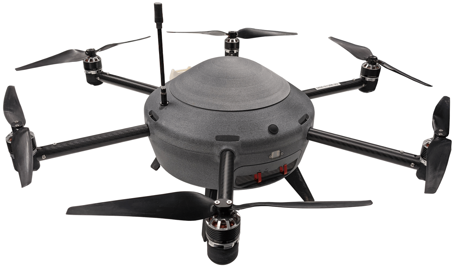
In the spirit of world-renowned Swiss quality, with our Meteodrones we have fully committed ourselves to the development of a unique measuring technology for the most accurate weather data.
Meteodrones are Swiss design and engineering: from the initial idea to the latest product, we develop our weather drones completely independently and in-house in St. Gallen, Switzerland. A highly trained, highly motivated team with an affinity for technology develops, designs and produces the drones according to Swiss precision and creates a technology that underlines our innovative spirit.
With our Meteodrones, we now reach an altitude of 6000 metres. By continuously improving the airframe, reducing the weight of the components and using the latest battery technology, we now offer two powerful systems whose different characteristics allow them to be used for different applications.
Innovative Measurement Technology With Weather Drones
Make weather forecasts even more accurate in the future - with Meteodrones!


We want to make weather forecasts even more accurate in the future. That is why we are the only company in the world to collect atmospheric data with our self-developed and autonomous weather drone system "Meteodrones".
The Meteodrones allow us to collect weather data from higher, but relevant layers of the atmosphere, by taking a transverse measurement of the atmosphere up to 6 km high.
This makes it possible to take precise and direct measurements of temperature, humidity, and wind at altitudes of up to 6 kilometers, for the first time. The measured data is then fed into our in-house developed and high-resolution weather models.
Make Forecasts of Extreme Weather Conditions More Precise
Our goal is to calculate high-resolution weather models for the largest possible areas and refine them with the innovative measurement technology of our weather drones. This approach has been proven to lead to unprecedented accuracy of weather forecasts. Especially on a local level for forecasting fog, thunderstorms, hail and heavy rain.
Advantages of Our Meteodrones at a Glance:
- record weather data in the lower and middle atmosphere
- enable hyperlocal measurements
- can be operated manually or remotely
- measure the local column of a location (fly straight upwards)
- detect the weather situation in remote, hard-to-reach places

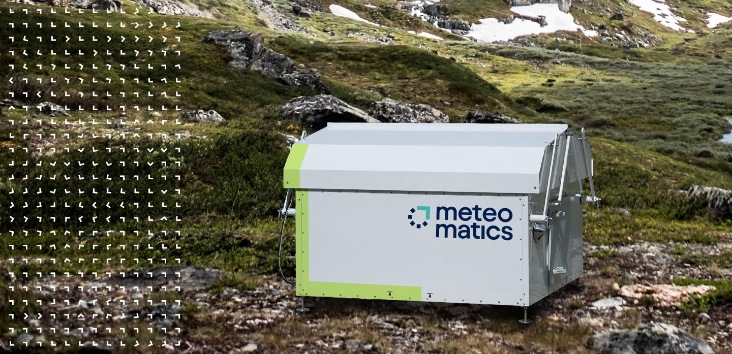
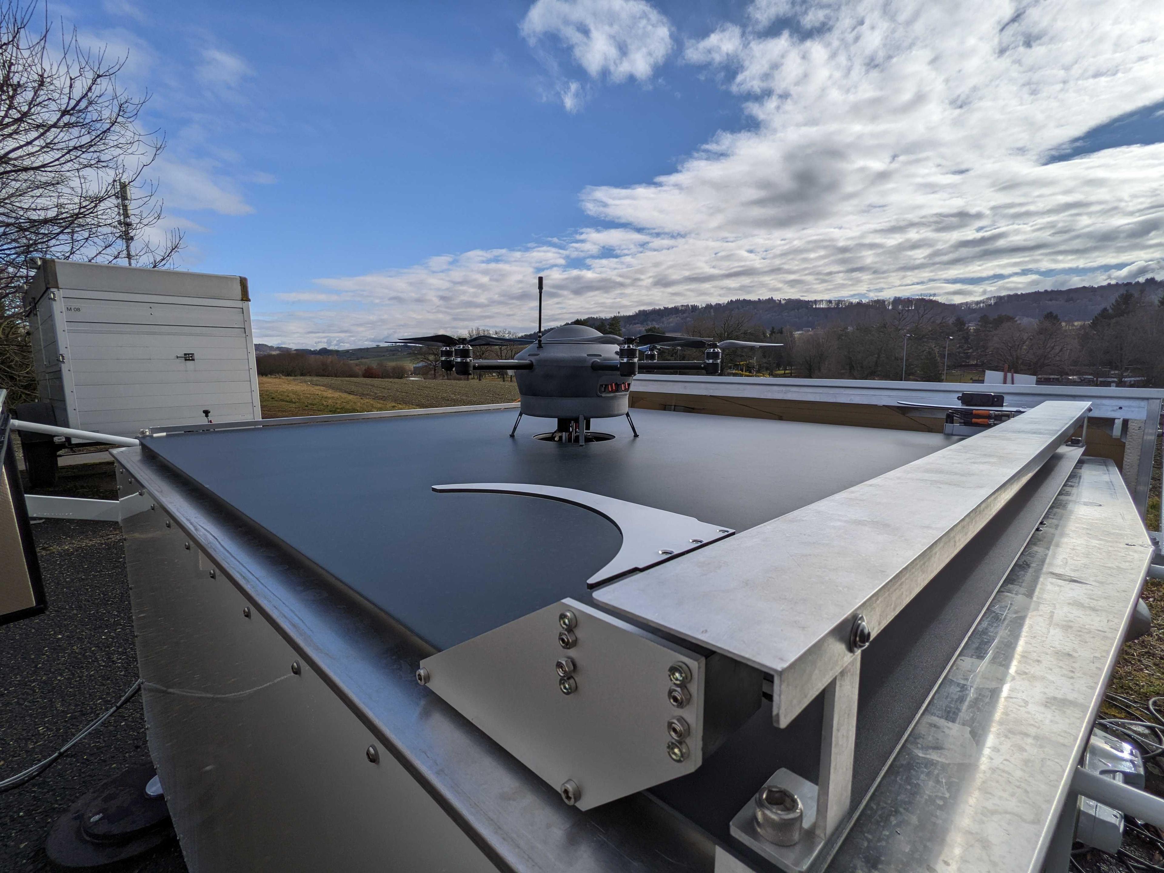
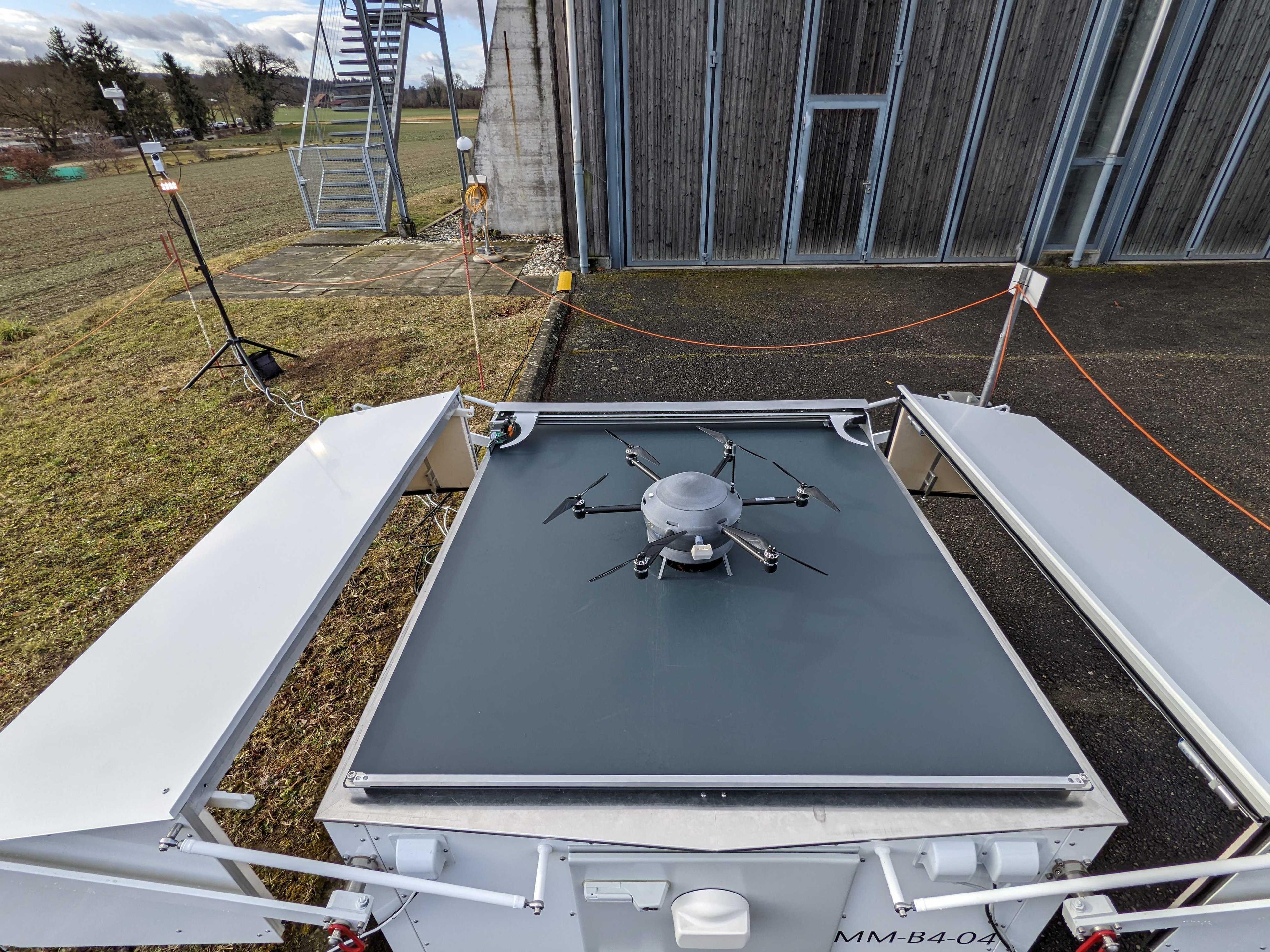
Meteobase
Since the start of operational drone flights in 2016, every Meteodrone flight has had to be controlled by a pilot. An important step towards nationwide drone deployment was the development of the Meteobase. It enables autonomous drone measurements and is also the drone's "home" from which it takes off, lands and its battery is charged.
As a ground station, it serves as local support for the operation of the Meteodrones. It serves as a communication element between the pilot and the drone or works as a control element for autonomous flights of the drone. The Meteobase consists of a central computer that performs various tasks related to the operation, control and maintenance of the drone and the monitoring and logging of weather parameters at the site.
It also includes the complete launch and landing platform, including the charging station, radio link and ground station, as well as cameras to monitor the immediate surroundings of the box. The cameras make it possible to verify correct landing and visually check the general condition of the weather drone. In addition, the station includes internal climate control (heating, air conditioning) to ensure optimal climatic conditions for the Meteodrones, their electrical components and the batteries. The base is waterproof and snowproof. Rain gutters ensure the drainage of rainwater. Once installed on site, the Meteobase remains permanently or until the end of a time-limited mission.
In 2017, the first prototype of the Meteobase was developed and tested under real conditions. With the help of the Meteobase, the collection of weather data can be expanded in the future.
With the Meteobase, we are aiming for nationwide drone operations and would like to contribute to making weather forecasts considerably more precise with autonomous drone missions. Our vision is a network of Meteobases to automate and remotely control weather drones. The Meteobase will eventually enable simultaneous remote operation of up to 10 different drone systems by just one pilot: at any time, from any location.


Doctoral student in atmospheric science
ETH Zürich
Meteodrones from Meteomatics are reliable and easy to use. In addition, the meteodrones have significantly advanced our research and enabled us to explore new possibilities in atmospheric measurement.
Weather Models
At Meteomatics we offer a wealth of different weather models. These include the widely used models such as ECMWF, DWD-Icon, GFS, HRRR, UKMO and many more. In addition to third-party weather models, Meteomamtics also calculates its own high-resolution weather models.
Meteomatics Weather Models
Based on a combination of different data sources, Meteomatics calculates weather models with a resolution of one kilometer. A resolution of one kilometer means that there is at least one validation or grid point within one kilometer that is included in the calculation of the weather model. This requires huge amounts of data processing capacities, but leads to a strong improvement of the forecasts, especially on a local scale. Meteomatics can calculate models with one kilometer resolution for any area in the world (upon request).
Swiss1k – High resolution weather model for Switzerland
Since we are at home in Switzerland and have many customers here, we offer a high-resolution weather model with a resolution of 1 km for the whole of Switzerland, which we call Swiss1K. This model is available in our API and is enriched daily with data from our Meteodrones.
EURO1k High-Resolution European Weather Model
EURO1k is an extremely high-resolution weather model for all of Europe, which is calculated by our team of experts to a resolution of 1 km. This resolution is unique for a European weather model. Additionally, the model is recalculated every hour to provide to most update short-term forecast possible. The EURO1k from Meteomatics is thus able to produce highly precise forecasts spatially and temporally throughout Europe, and this completely individually for relevant sectors.
Meteomatics Mix - The best combined output from all sources
The Meteomatics Mix combines different models and sources into an intelligent blend, such that the best data source is chosen for each time and location. The length of the forecasting period as well as the spatial resolution depends on the model from which the requested parameters originate.
Third Party Weather Models
Here at Meteomatics you get all weather models that are interesting for you. We offer over 25 different models and over 60 different data sources. These include the widely used models such as ECMWF, DWD-Icon, GFS, HRRR, UKMO and many more. A full list of Models and Sources can be found in our Weather API Documentation in the sub-section models and data sources.
Accuracy Redefined
Meteodrone Data Combined With High-Resolution Weather Models
The combination of our self-developed high-resolution weather models enriched with data collected by our drones, further improves the data basis of the models. This is unique worldwide and leads to an unprecedented accuracy of the forecasts.
Thanks to data with a resolution of up to 1 km, our weather model can make very precise forecasts. High-resolution forecasts such as these open up new possibilities for the energy and water industries in particular, such as the spatial resolution of precipitation.
The high-resolution EURO1k model in combination with the drone data also excels in specific forecasts of fog formation, icing, as well as thunderstorms and lightning for airspace surveillance.
Data Delivery and Performance
"We make weather data accessible - fast and easy", this is the credo with which we design our services. For this reason, customers can obtain weather data from us in the desired format in real time, flexibly and quickly via just one interface. Our weather API is built on a strong performance architecture, allowing down-scaling and calculations in real time and data output in just a few milliseconds.
Our data is reliably available. Our API had an up-time of 99.97% in 2021. In addition, our offers and services have also been certified by external authorities.
Verifications
In everything we do, we try to be as scientific and accurate as possible. Of course, science also means transparency. We therefore take great pains to document our work and make it transparently available. In addition, we also publish our results in scientific and peer-reviewed journals. Follow the links if you want to learn more.

Talk to an Expert