
09/15/2025
Why This Hurricane Season Feels Different and What’s Coming Next

Director of Marketing & Communications, North America
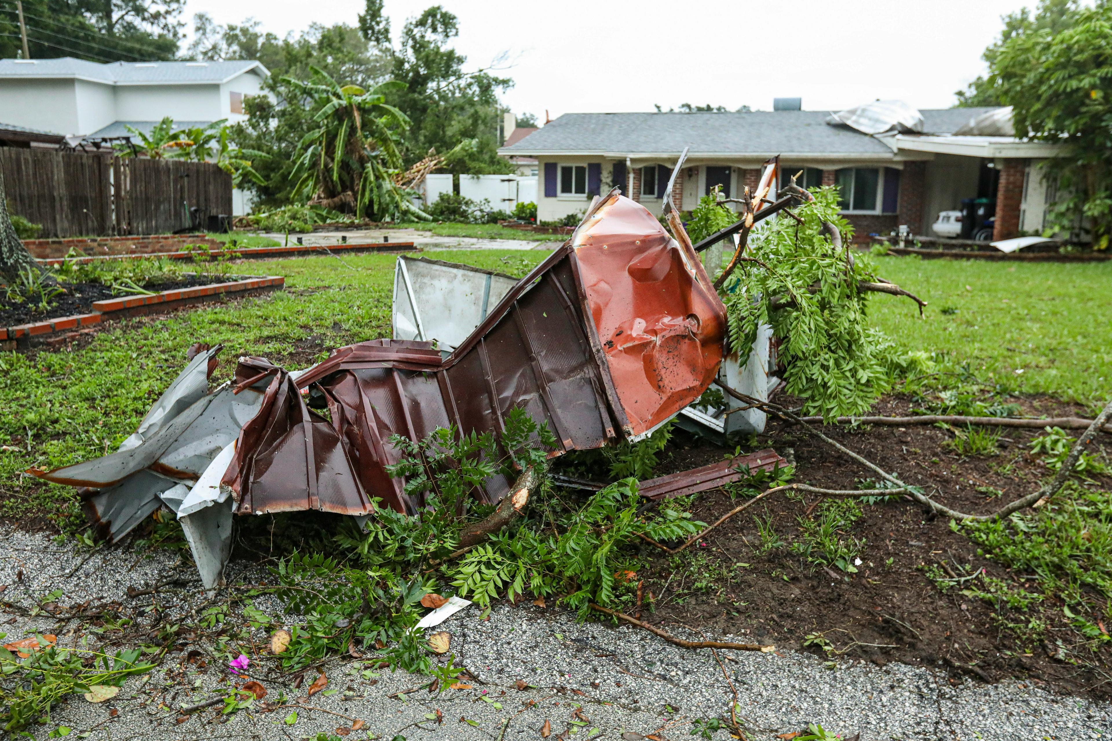
As of early September, the 2025 Atlantic hurricane season has been unusually quiet, but that calm may be setting the stage for a stormy finish. With the climatological peak underway, forecasters are watching for a sharp uptick in activity. We sat down with Eric Blake, a Senior Hurricane Specialist at the National Hurricane Center (NHC), and Chris Hyde, Senior Meteorologist at Meteomatics.
An Unexpected Calm — But Not for Long
“It is a little eerily quiet,” Chris Hyde said. And that’s despite conditions that should have favored more tropical activity by now. Eric Blake agreed: “We’ve been pretty fortunate so far this season.”
The current lull is likely tied to a negative Madden-Julian Oscillation, but that pattern is beginning to shift. “You’re starting to see activity in the Eastern Pacific with Kiko and Lena,” Blake noted. “That usually means the Atlantic will follow soon.”
Want to hear the whole story in their own words?
Hear it from the experts: In this September 2025 conversation, Eric Blake of the National Hurricane Center joins hosts Jim Robinson and Chris Hyde to break down this season’s patterns, what’s changing, and where forecasting is headed.

Lessons from Katrina & Rita


Blake’s career at the NHC began in 2000, and few seasons loom as large as 2005. “Katrina is a hard one for me,” he said. “I’m originally from the New Orleans area… telling family to get the heck out of there, that was traumatic.”
He recalled working the radar as Katrina made landfall. “It’s nice to remember how far we’ve come. The hurricane program is a lot better now, but it’s hard to look back.”
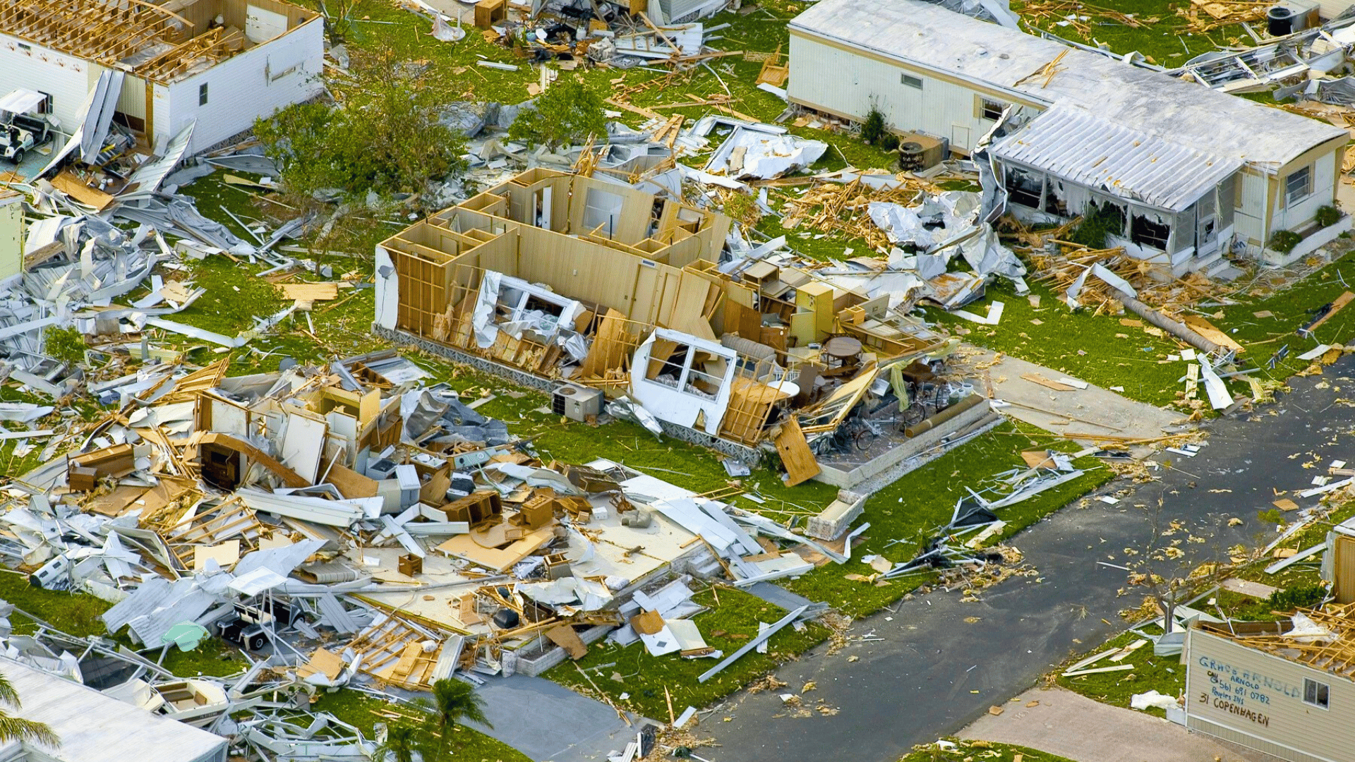
Just weeks after Katrina came Rita. “I was at a funeral when I heard Rita had dropped to 898 millibars,” Blake said. “The evacuation ended up killing more people than the storm itself.”
Both events changed how officials—and the public—respond to storms. “We had the confidence to avoid evacuating Houston during Laura, even though it hit nearly the same spot,” Blake explained. “That wouldn’t have happened in 2005.”
The Cone Isn't the Whole Story
Forecasts are getting more accurate, and the “cone of uncertainty” has shrunk to reflect that. But Blake warned that this can backfire. “We’re a little bit of a victim of our own success. The storms aren’t getting smaller, just the cone.”
People often misinterpret the cone as showing where the danger is. It doesn’t. “We’ve added things like the area of tropical storm force winds, but hazards can extend far outside the cone,” Blake said.
Hyde emphasized the human angle. “It’s easy to see a graphic and say, ‘That looks bad.’ But what people forget is that forecasting isn’t just about data—it’s about impact. Businesses are planning around these storms. That’s where communication has to be spot-on.”
More Than Just Wind Speed
“People still focus too much on the top wind speed,” Blake said. “But whether that wind extends 10 miles or 50 makes all the difference—especially for storm surge.”
Hyde agreed and pointed to recent improvements in resolution. “We just launched our US1k model. It’s based on the EURO1k framework but focused on the U.S., updating every hour with 15-minute detail. It gives you a clear picture, especially when timing matters.”
Both emphasized the importance of better tools. “Every new tool that moves the needle—I’m interested,” said Blake.
The Climate Connection
Rainfall from tropical systems has been increasing over the last few decades. “We’re seeing more rainfall now than we were 30 years ago,” Blake said. “How much more—whether it’s 5% or 25%—is still being studied.”
Sea level rise also affects outcomes. Even if the storm stays the same, higher water means higher surge.
Chris brought up another trend. “In the energy sector, there’s been a shift. People used to focus on wind impacts, but now it’s rainfall and flooding that are driving big decisions—especially with refining and infrastructure.”
Blake added, “Some research even suggests storms are moving more slowly in mid-latitudes, which can increase rainfall totals. It’s not conclusive yet, but it’s a concern.”

Senior Sales Manager, Meteorologist
US1k gives us a level of granularity that’s essential for U.S. storm forecasting. It updates every hour, includes 15-minute steps, and helps us deliver clarity where timing matters most.
What the Next 25 Years Could Bring
Blake is optimistic about where forecasting is heading. “We’ve come a long way in 20 years because of investment in satellites, aircraft, and modeling. It wasn’t an accident. It was a group effort.”
Looking ahead, he hopes for even earlier warnings. “Maybe in 25 years we’ll have 10-day forecasts that we really trust, even before a storm forms.”
Hyde sees AI playing a significant role. “We’re already integrating models like GraphCast and FourCastNet into our API. That’s helping forecasters, but also businesses that need lead time to make operational decisions.”
Blake added, “We’re improving 3 to 4% every year. That adds up. We’ve already passed the old limits people thought were unbreakable.”
Hyde wrapped it up with a grin: “Yeah, I’ll just cross my fingers and hope for a quiet rest of the season—but I don’t think that’s going to happen.”
Supporting Smarter Decisions This Hurricane Season
As hurricane season intensifies, access to accurate, real-time weather data becomes critical. Meteomatics delivers high-resolution forecasts through our Weather API, with over 1,800 parameters available on demand—covering everything from wind speeds to precipitation, storm surge potential, and more.
At the core of this offering is US1k, our proprietary 1-kilometer resolution weather model tailored for the contiguous U.S. and Gulf of Mexico. With hourly updates, 15-minute time steps, and downscaling to 90 meters, US1k provides unmatched insight into localized conditions, enabling organizations to track storm developments with greater confidence.
Whether you’re managing infrastructure, energy production, logistics, or emergency response, Meteomatics equips you with the tools needed to make informed, timely decisions when it matters most.

Expert Call
Let’s Find the Perfect Solution to Your Problem. Talk to an Expert.
Related Articles


We provide the most accurate weather data for any location, at any time, to improve your business.


