
09/08/2023
Hurricanes Explained
Formation, Seasonality, and Preparation with Weather Data

Hurricanes are amongst the most violent and damaging of Earth’s natural disasters. Fortunately the mechanisms which cause them to develop are well understood, and the behavior of a hurricane over its lifetime can be well predicted by modern weather models. In this article we describe what hurricanes are and how they are formed, as well as how weather data can be used to mitigate their impact.
What Is a Hurricane?
A hurricane is an intense tropical cyclone. Specifically, hurricanes form in the Atlantic and Eastern Pacific oceans — the same phenomena can occur elsewhere on the planet, but they are given different regional names. To be classified as a hurricane, a tropical cyclone needs to achieve wind speeds exceeding 119 km/h (74 mph).
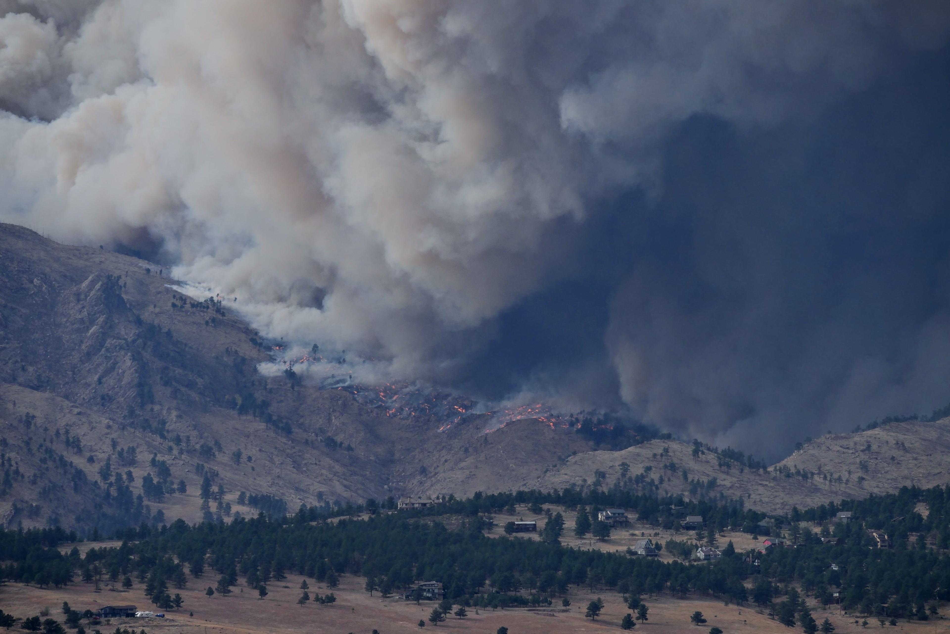
Hurricane Lee
(Update: September 11, 2023) Hurricane Lee is moving at 7 mph NW and is expected to shift in a slow west-northwest direction before gradually turning north by midweek. Lee will pass well north of the northern Leeward Islands, the Virgin Islands, and Puerto Rico on its forecasted path. The storm is a Category 3 hurricane on the Saffir-Simpson scale with maximum sustained winds near 120 mph, with even higher gusts expected. Hurricane-force winds extend to 75 miles from its center, and tropical-storm-force winds reach 185 miles. The storm's minimum central pressure is estimated to be 950 mb. Hazards affecting land primarily include dangerous surf and rip currents generated by Lee, impacting various islands in the Caribbean as well as the southeastern coast of the U.S.
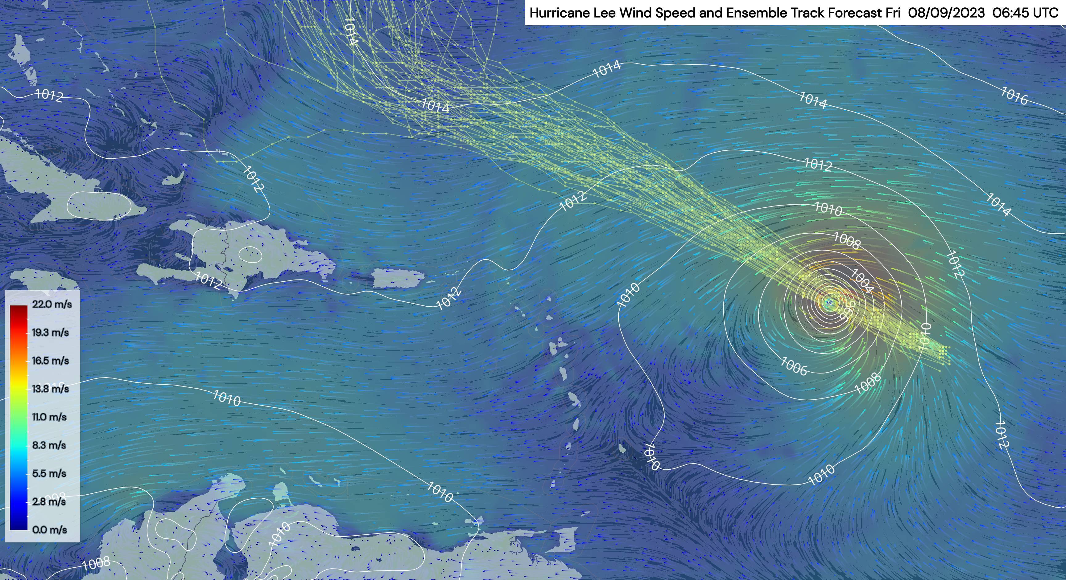
On September 8, 2023, Hurricane Lee was located in the eastern Caribbean and was projected to recurve along the east coast of the United States.
How Do Hurricanes Form?
Hurricanes form from tropical cyclones. A cyclone is the name for a low pressure system. Fluids like air tend to flow from regions of high pressure towards regions of low pressure. However, in the Earth’s atmosphere, the spinning of the planet adds a coriolis force which partially balances the pressure gradient force (the suction of the low pressure). This causes air to circle around the low pressure region as it moves inwards, creating the familiar swirling pattern of cyclones. As the air converges at the local pressure minimum, the inward rushing air has to go somewhere (otherwise all the air on the planet could ultimately be collected in one place). The effect is that air at the center of a cyclone is pushed upwards by the converging surface winds.
In the tropical ocean the sea surface is warm, and evaporating water provides more energy to the atmosphere, with the effect that pressures deepen and cyclones can become much more intense. When this happens, the storms are designated one of several intense weather names and categories, depending on local conventions. In the Atlantic and Eastern Pacific, these tropical storms are called hurricanes (which probably derives from the name of a native Caribbean god of destruction); in east Asia the common term is typhoon.
What Causes Hurricanes?
The root cause or "seed disturbance" which leads to the formation of hurricanes may be one of several features. Examples include African Easterly Waves and depressions in the Intertropical Convergence Zone amongst others. The important thing is that a near-surface feature has enough vorticity (tendency of wind to circulate around a central point) and convergence (tendency of wind to draw in towards the central point).
When this occurs over the tropical ocean, spiraling winds carry warm, moist air towards the center of the cyclone. Warm air is more energetic than cold air, and moisture (evaporated water) also contains energy in the form of latent heat (since energy is required to evaporate the water, and this is stored in the water vapor). The transport of warm air fuels the cyclone directly and, when lifted at the center of the storm, the moisture which condenses out of the air back into liquid water releases its stored energy, all of which contributes to the violent nature of hurricanes.
What Does a Hurricane Look Like?
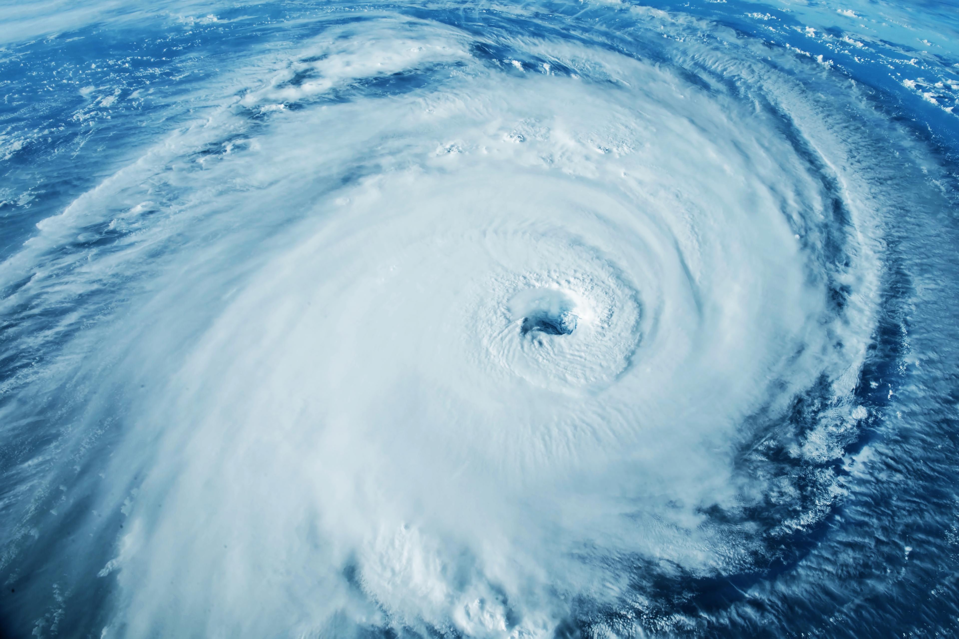
From space, hurricanes look similar to extratropical weather systems (because these are both examples of cyclones). Clouds spiral around the low pressure center - anti-clockwise in the northern hemisphere and clockwise in the southern hemisphere. The clearest difference between a hurricane and an extratropical cyclone is the eye - a cloud free region in the center of the storm which is not present in the extratropical cyclone.
From the ground, a hurricane looks like a wall of rain and destructive wind, although it is true that wind speeds drop to a calm breeze in the eye of the storm.
What Is the Eye of a Hurricane?
The eye of the hurricane is the region in the center of the storm where winds are very still. Often no cloud forms over the eye, which is typically 30-60 km (18-37 mi) wide, making it a very recognisable feature of hurricanes. Sometimes the eye is covered by upper level clouds, making it hard to see from space (but still visible on radar images). Sometimes shear in the hurricane makes the eye (which is essentially a cloud-free circular tunnel connecting the surface and upper levels of the hurricane) align diagonally instead of vertically, which also makes it difficult to spot from above.

Where Do Hurricanes Form?
Whilst local pressure minima can be found all over the world, tropical cyclones, as the name suggests, can only form in the tropics. Furthermore, the supply of moist air required for the cyclone to develop into a hurricane can only be sustained over the oceans.
Two further constraints limit the regions where hurricanes can form: one physical; the other etymological. The coriolis force needed to keep the cyclone spinning, fulfilling the vorticity requirement, increases with distance from the equator. Near the equator, the coriolis force is so weak that hurricanes typically cannot form within 5 degrees of the equator.
To be etymologically pedantic about things though, 'hurricane' is the name given specifically to tropical cyclones occurring in the Atlantic and Eastern Pacific. For this reason, whilst tropical cyclones can occur in all of the tropical oceans, hurricanes can only technically form in the basins which affect the Caribbean and North America.
What Is the Wind Speed for a Hurricane?
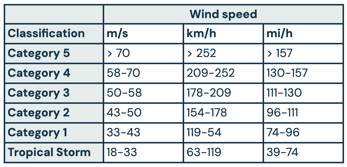
In order to be classified as a hurricane, a tropical cyclone must have one-minute sustained wind speeds in excess of 119 km/h (74 mph). This is enough to qualify as a category 1 hurricane. Higher wind speed thresholds are required to register in different categories. Of course, in order for a hurricane to be classified as category 5, it must at one point have been a category 1, and must also later return to category 1 during the dissipation of the storm.
What Are the Categories of Hurricanes?
Tropical storms are categorized based on the speed of the winds involved, and will change category over their lifetimes. For hurricanes affecting the United States, the Saffir-Simpson scale is used, which ranks cyclones from a tropical storm through five categories of hurricane depending on the maximum wind speed to be sustained over one minute.

How Long Do Hurricanes Last?
The longest lived tropical cyclone on record occurred this year in the Indian Ocean. Cyclone Freddy, had it occurred in the relevant basin, would have peaked at a category 5 hurricane, and lasted for 37 days. The longest lived legitimate hurricane was Hurricane John, whose existence in 1994 spanned 31 days.
However, these two examples are outliers, and the vast majority of hurricanes last for two weeks or less. During their lifetimes, they will also change category, and do not maintain their most intense phase for long - the longest sustained category 5 on record was 77 hours long, but typically category 5 storms reduce in intensity after about 24 hours.

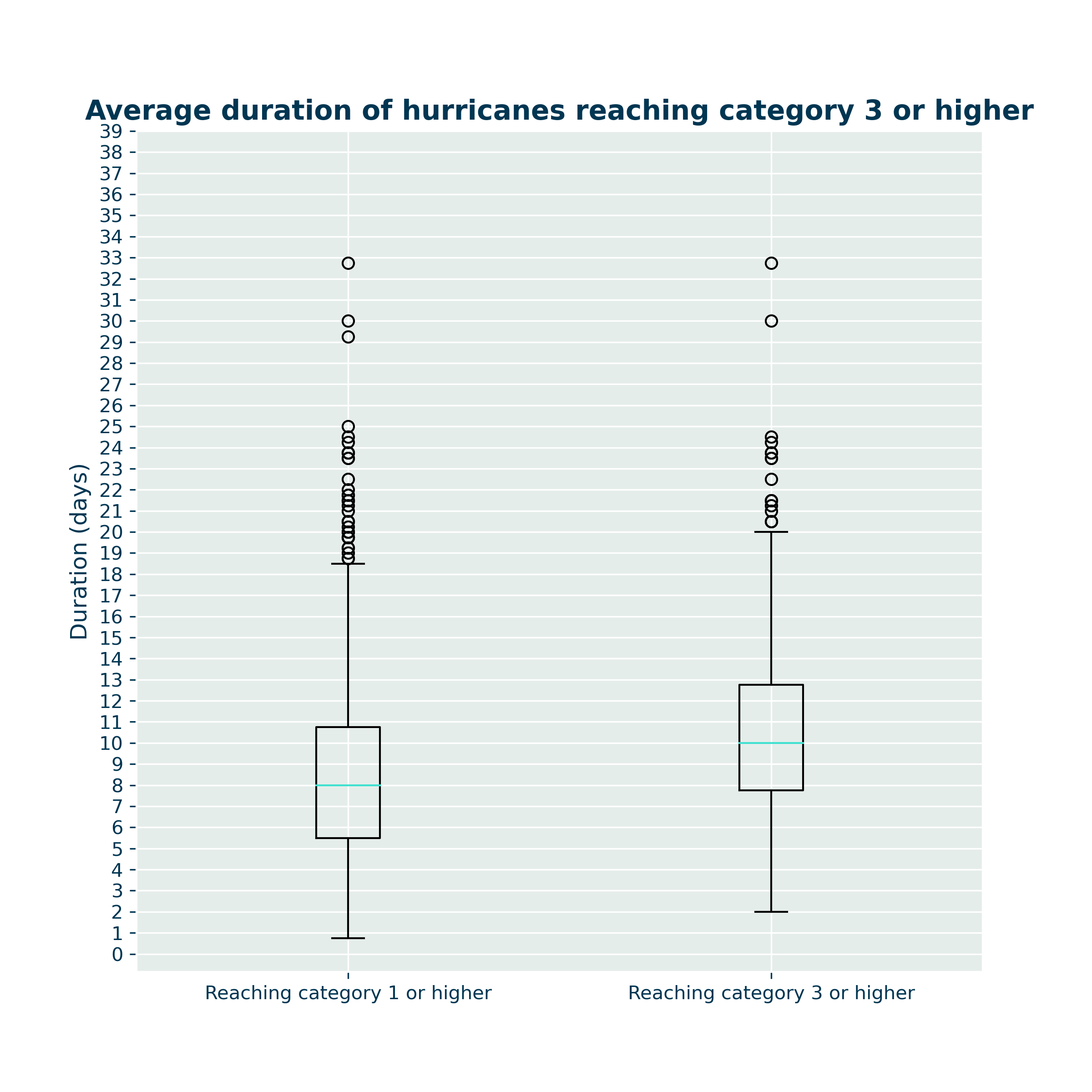
Hurricanes grow from tropical depressions. They become Category 1 hurricanes when their sustained wind speeds cross a threshold of 119 km/h. Some will intensify further becoming Cat 2, 3, 4 or even 5. So all Category 5 hurricanes were once Cat 1, but the same is not true the other way around.
This plot shows the distribution of lifetimes for all storms in the HURDAT2 data record which ever became Category 1+ (LHS) or Category 3+ (RHS) hurricanes. The blue line shows the median lifetime of a storm, with 50% of the storms having lifespans within the box. The lifetime includes time spent as a tropical depression before and after being classified as a hurricane. As you would expect, the storms which were ever classified as category 3+ is a subset of the storms which were ever classified as category 1+, since a storm must pass through category 1 in order to reach category 3.
How Are Hurricanes Named?
Hurricanes are named from predetermined lists of names. These lists consist of alternating male and female names and are organized alphabetically. Each year, a new list is used, and the names are reused every six years unless a storm is particularly deadly or destructive. In such cases, the name may be retired and replaced with a new one to avoid confusion in the future.
The practice of naming hurricanes began in the early 1950s. Prior to the practice of naming hurricanes, they were often referred to by their location or description. The primary reason for naming hurricanes was to enhance communication and public awareness. When a storm has a name, it becomes more relatable and easier to remember.
Names are typically chosen to be short, easy to remember, and culturally sensitive, considering the diverse range of communities affected by hurricanes. For example, names from various languages and cultures are included to reflect the global impact of these storms. In the event that there are more hurricanes in a season than there are names on the list, additional storms are named using the Greek alphabet, as happened in the exceptionally active 2005 Atlantic hurricane season.
Initially, only female names were used. However, in 1979, the naming system was updated to include both male and female names in a rotating list. This change was made to eliminate any gender bias and promote gender equality in the naming of storms.
When Is Hurricane Season?
When Is Peak Hurricane Season?
Tropical cyclones and hurricanes can and do occur at all times of year. However, the National Weather Service and associated bodies in the United States define a hurricane season, adopted by convention, as this is when most hurricanes occur.
When Does Hurricane Season Start?
The start of the official hurricane season is on the 1st of June, but hurricanes can occur before this date, as the tropical pool where they form is warm all year round.
When Does Hurricane Season End?
The end of the official hurricane season is on the 30th of November, but tropical cyclones can develop into hurricanes after this date too, as the conditions for their genesis are met all year round due to the stability of weather in the tropics.
What To Do During a Hurricane?
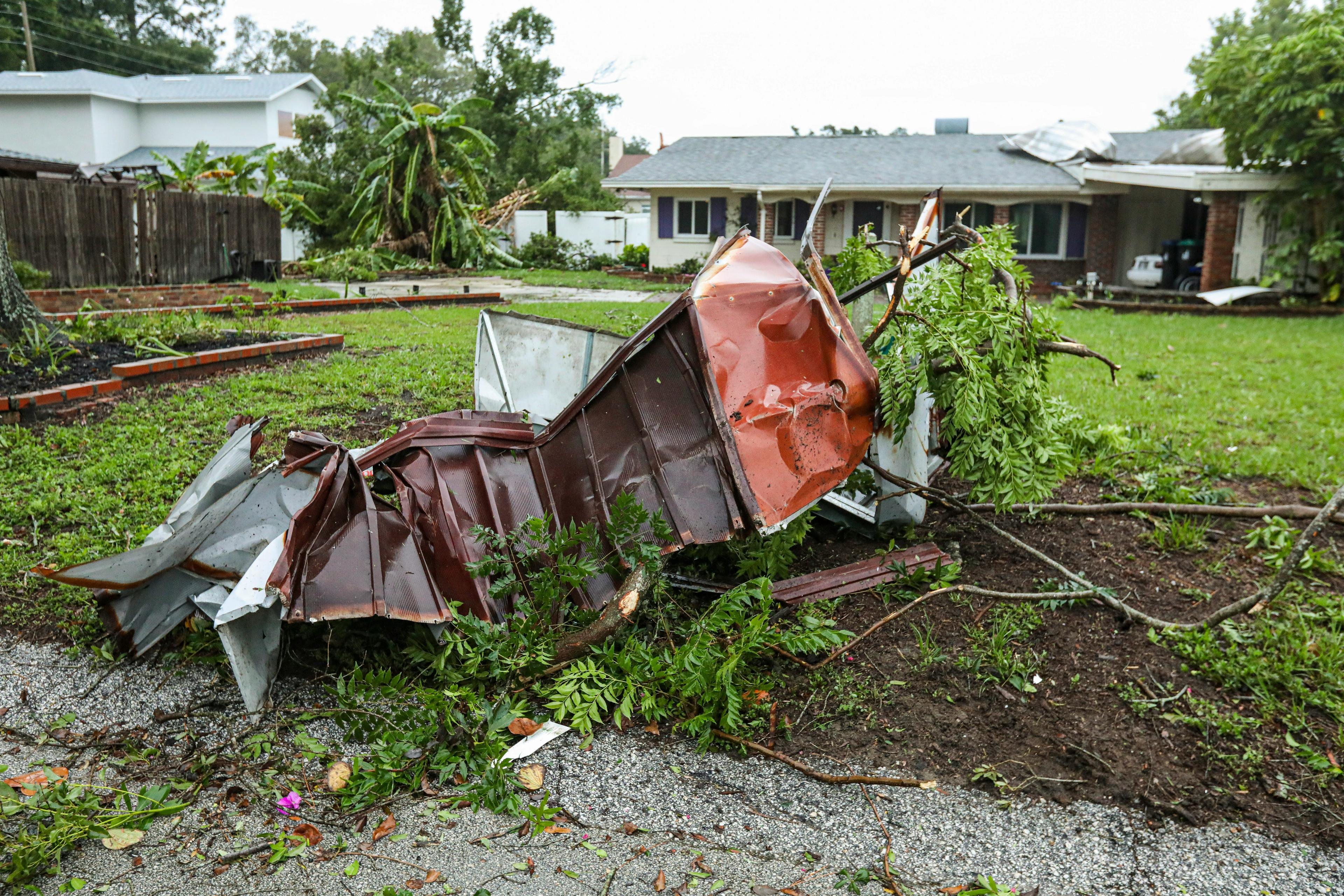
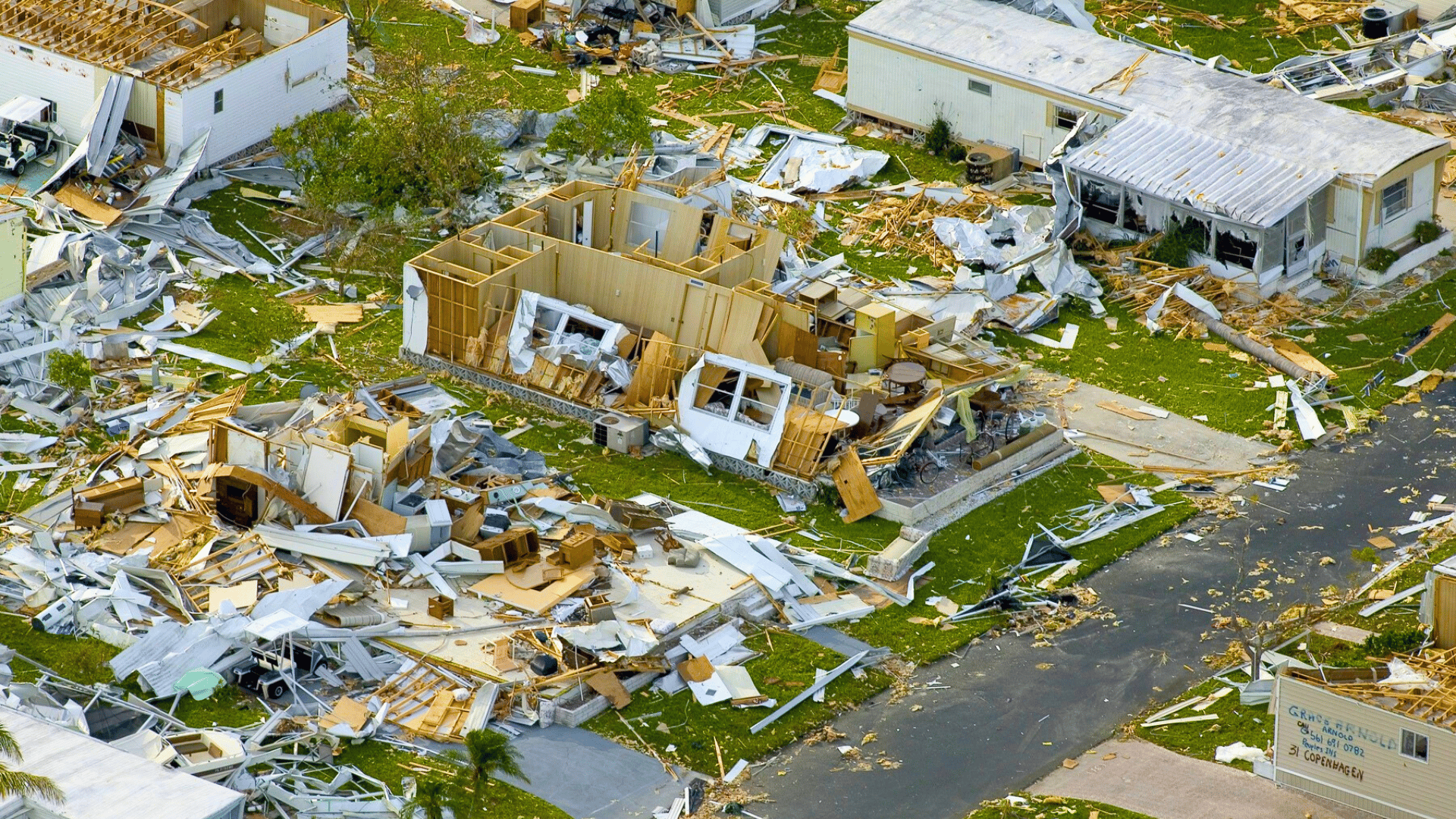
Hurricanes are amongst the most violent of Earth’s natural hazards - the winds alone carry as much energy as about half the electricity, and when you consider the energy contained in the condensing moisture, the number approaches 200 times that capacity. Not all of that energy is released at once, but this dissipation is rather spread out over its entire lifetime. However, they’re still incredibly dangerous, and should be approached with care.
If you find yourself in the path of a hurricane and unable to escape, the first and most important thing to remember is to take refuge indoors, away from windows and any glass that could shatter. An interior space like a bathroom or sturdy closet is recommended to protect you from falling debris.
You are advised to use battery powered flashlights for lighting - it is likely that electricity will be cut off by the storm, but using candles can do more harm than good if a flame gets out of control.
Floodwaters are also to be avoided. In the event that you are cut off from others by water, stay put and await rescue. Swimming or even just wading through flood waters can be incredibly dangerous, as you may easily be swept away without warning.
How Does Weather Data Help Dealing With Hurricanes?
Weather data is used at all three stages in the impact of a hurricane:
Before a hurricane makes landfall, weather forecasts can predict where the storm will pass and what conditions to expect. This allows governmental agencies and individuals to prepare for the coming storm, for instance by reinforcing levies with sandbags. In the event of severe hurricanes, evacuations will also be recommended, and advanced warnings of where storms will head facilitate better organized, less panicked evacuation plans.
During the hurricane the progress of the storm will be monitored in order to dispatch emergency services to appropriate locations: those which have recently been affected but are also safe to approach for rescue. Individuals taking shelter from the storm will also want to monitor the passage of the hurricane so that they know when it is safe to emerge.
After the storm further relief efforts will need to be made, and a detailed analysis of the impacts of the storm help to coordinate this. In the slightly longer term, weather data will also be used by insurance companies to determine the validity of claims and magnitude of payouts. The MetX Claims tool from Meteomatics is one easy interface that insurance providers can use to examine extreme weather for insurance claim validation.
Weather data from Meteomatics is available at the click of a few buttons thanks to our easy-to-use URL Creator. Check it out, and see the power of easy to use weather data for yourself!

Talk to an Expert
Related Articles


We provide the most accurate weather data for any location, at any time, to improve your business.


