02/07/2023
Meteomatics Weather Data for Defense Applications
The Military Turn to Meteomatics for Weather Data

Sr. Content Marketing Manager
At Meteomatics, we see the impacts of weather on every industry daily. For the defense sector, these impacts can be catastrophic. Often, data from national meteorological services alone is not enough for complex defense applications. Meteomatics' technology improves the accuracy of weather forecasts with in-house developed weather drones and a high-resolution European weather model, helping ensure the success of operations in the air, on land, and at sea.
The Weather Has Dramatic Effects on Military Outcomes
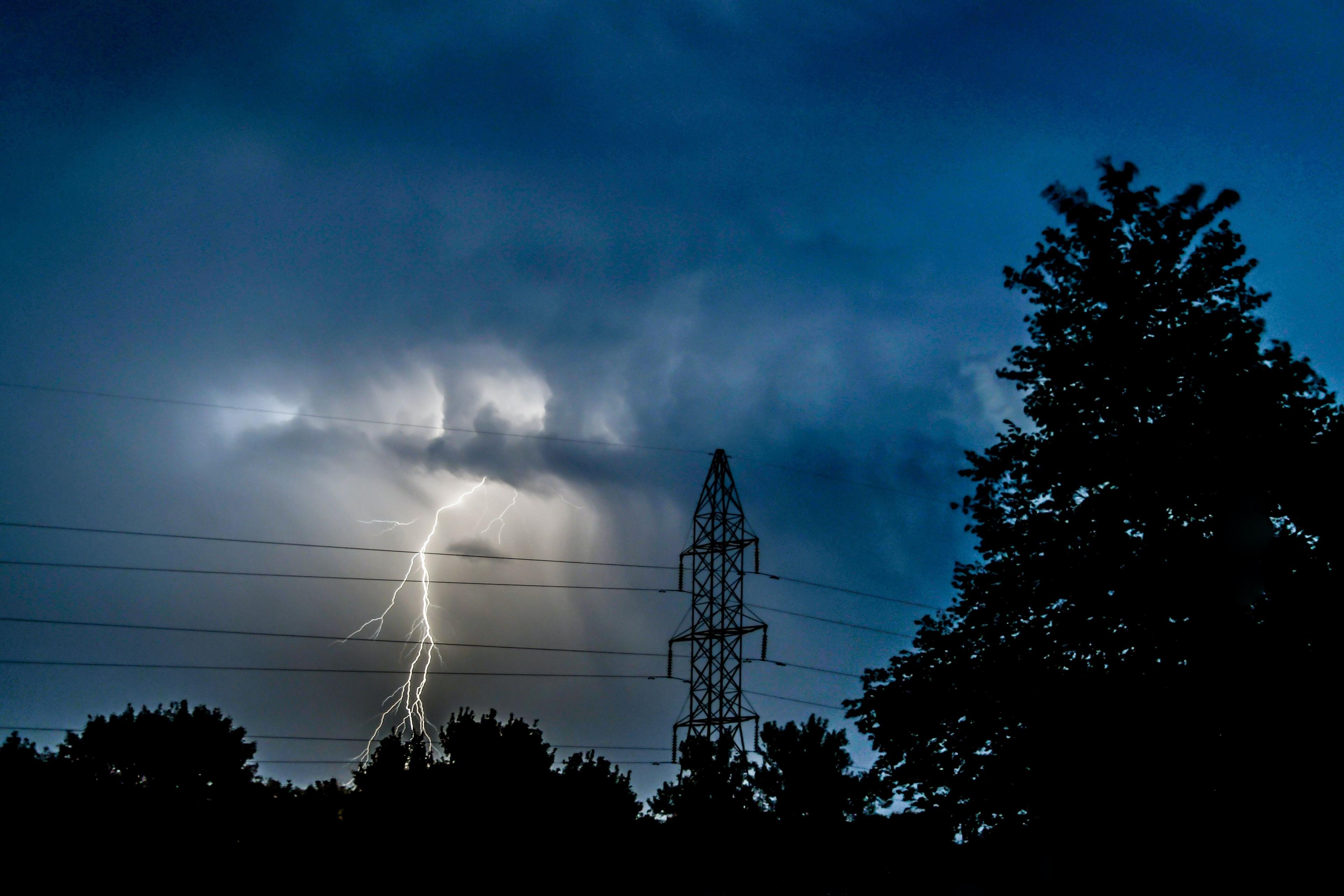
Weather conditions have often determined the course of history, deciding the outcome of many pivotal battles. In 1415, in the Battle of Agincourt, the heavily armoured French knights were trapped in a muddy field after a storm, leading to the unexpected victory of England. In 1588, severe sea storms broke the Spanish Armada, stopping Spain from overthrowing Elizabeth I. In 1805, Napoleon used the cover of fog in the Battle of Austerlitz to quietly move his troops and take the Austro-Russian army by surprise. The list is long.
Over hundreds of years, armies had to cope with the weather’s unpredictability. Thus, not surprisingly, the military nurtured the progress of weather forecasting technology. The first national meteorological services created in the 19th century – the American Weather Bureau and the British Met Office – were overseen by the navy, seeking to make ocean travel safer. In the 20th century, during World War II and the Cold War, the military supported the development of new tools, such as weather radars to detect rain, snow and hail, satellites to track meteorological events from above and models that calculate forecasts based on current conditions.
Today, most military forces in the world closely monitor the weather to avoid risks, ensure weaponry and vehicle performance and increase operational success.
Highlights
- Meteodrones provide hyperlocal weather data for operations anywhere, anytime.
- EURO1k and US1k provide high-resolution forecasts for effective operations.
- Meteomatics’ highly accurate data is a critical factor for mission success.
Meteomatics’ Technology Improves Weather Forecasting
Armed forces rely on national meteorological services and sometimes their own weather forecasting methods. However, these sources do not always provide the most accurate data. Traditional tools cannot collect reliable enough data from the lowest part of the atmosphere (up to 3 km aboveground), where thunderstorms, fog, hail, and other hazardous events form. Satellites, ground stations, and radars take measurements only remotely. Balloons and aircraft do it on-site, but only while launching or landing, limiting data measurement to short timeframes (meteorologists release balloons only twice a day) and specific locations (aircraft only take off and land at airports).
Additionally, national services cover limited domains centred around each country and use different weather models. For example, an aeroplane from Bern to London flies through three national weather model domains. These models calculate equations at different resolutions and blend data sources in slightly different ways. But in meteorology – the field that coined the term "butterfly effect" – the tiniest change in the initial conditions can lead to very different outcomes.
Military organisations work with Meteomatics to improve observations and forecasts. The United States, the Swiss Armed Forces, and many other allied forces and neighbours, as well as international manufacturers of military supplies are some organisations we collaborate with. Two of our in-house developed tools have been drawing their attention: Meteodrones and EURO1k.
Weather data makes the difference between the success or failure of an operation
Meteodrones
Meteodrones are drones that collect data from the lowest layer of the atmosphere. They fly through wind, storms and even icy conditions – they are the only weather drones with a de-icing system. Rotors allow them to rise in a straight line up to 6 km, measuring temperature, moisture, wind direction and speed, and atmospheric pressure at different heights as many times as needed. The data is encrypted and does not go to a server. Instead, analysts access it locally, and can then feed it into a weather model, providing fast input about current conditions and improving the accuracy of forecasts.

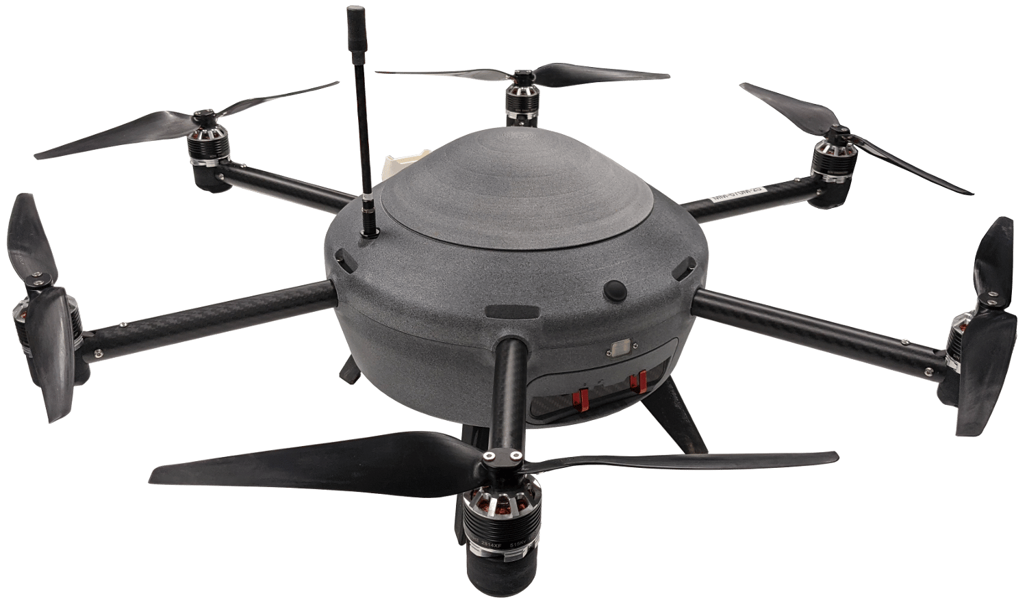
Meteodrones are used to support a wide range of military operations. As mobile weather stations, Meteodrones can fly in remote places where weather observations are scarce. But they are applicable anywhere. In missions with a target, like those in the paratrooper and artillery divisions, wind information helps prevent paratroopers from going astray, and projectiles from going off course. The drones support radar operators in spotting aircraft or missiles. The reach and precision of a radar depend on the atmosphere's density, which changes according to variations in temperature, moisture and pressure. In extreme situations, this creates a blind spot, and the radar misses an approaching enemy altogether. The same is true for laser systems or any method that detects objects by tracking sounds, as atmospheric conditions also determine the way light and sound travel through the air. The military use-cases are countless. Some are obvious, and others can be surprising, even for us: our team is currently working on electric field sensors that will warn about the likelihood of spontaneous lightning formation at rocket launches.
EURO1k
EURO1k is the only weather model that covers the whole European continent, plus North Africa, with a resolution of 1 km and hourly updates. All data points are no more than 1 km away from each other, and the model recalculates the forecasts every hour with the latest data received from weather sources. In meteorology, the closer the data points and the more frequent the updates, the better the calculations and the more accurate the forecasts. For comparison, most models' data points' distance ranges from 5 to 25 km, and the updates from 3 to 6 hours. The continental range of EURO1k allows strategists to analyse one single high-resolution source instead of many sources with different resolutions.
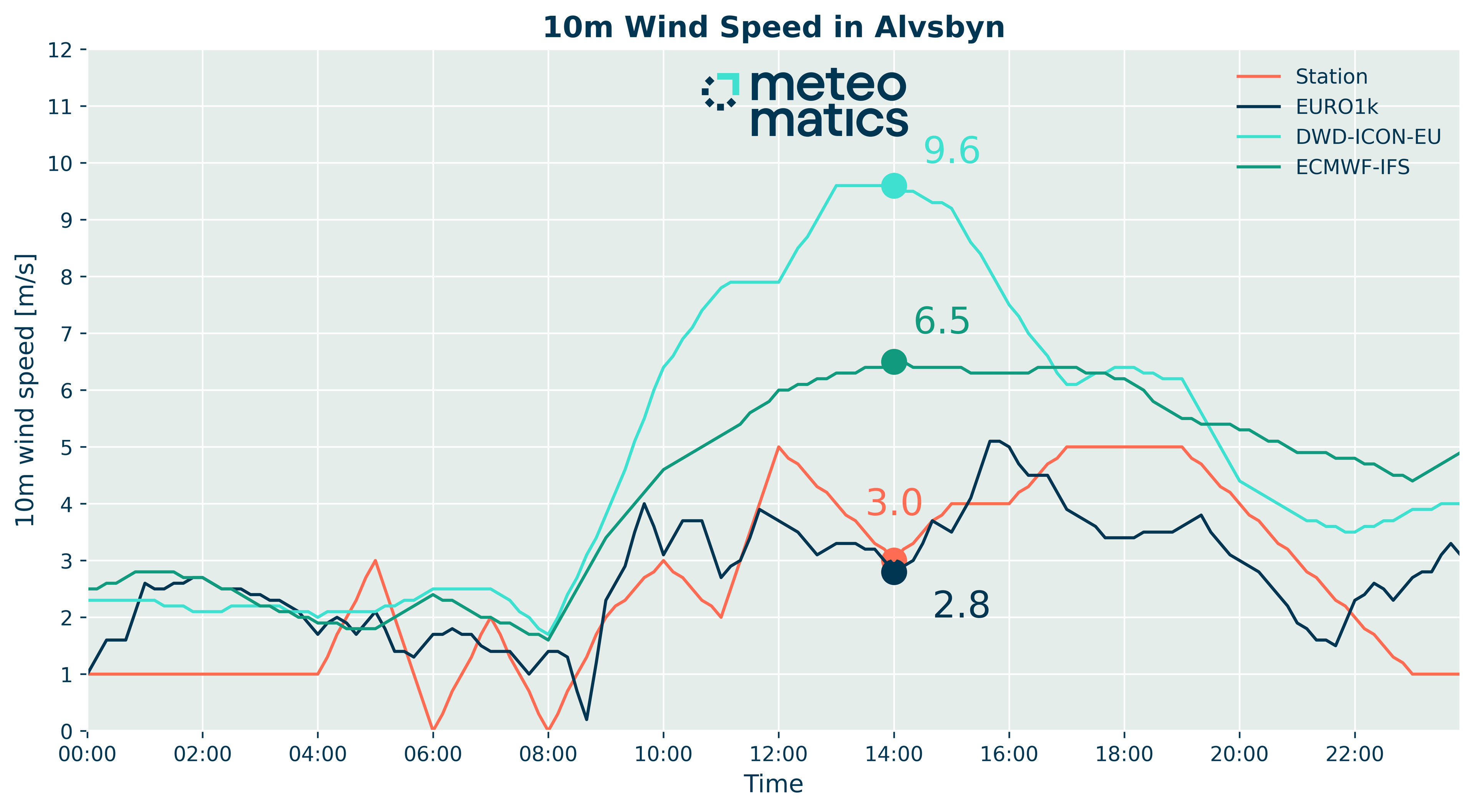
EURO1k's forecasts improve the execution of any military operation, from personnel training and weapon testing to rescue, defense, and incursion missions. The following illustrations compare the wind forecast for the northern Scandinavia region (where international forces train together in winter) from EURO1k and two of the most used weather models. EURO1k polishes the blur over land (areas covered in blue), offering a more detailed view of the conditions in the area.

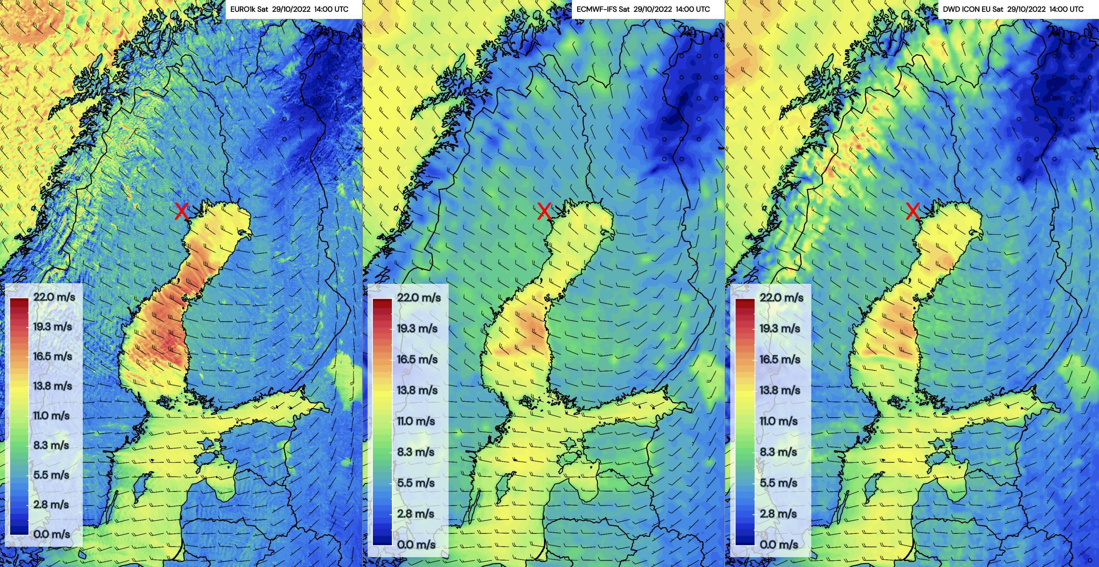
The red X spot marks the location of a weather station in the city of Älvsbyn, Sweden. The chart below shows how EURO1k outperforms the other models, getting closer to the true conditions, measured at the station throughout the day. The wind speed forecast from other models was around two or even three times higher than the forecast from EURO1k and the observed data, which makes a significant difference for operational planning and success.
Weather data makes the difference between the success or failure of an operation. And as these numbers show, EURO1k's higher accuracy increases the chances of success.

Climate Change Brings a New Challenge
The weather has impacted military operations since humanity started waging war. Armed forces finally started better handling weather events in the past century thanks to progress in meteorology. But their knowledge, tools, and methods will be challenged as the climate gets warmer. According to the Climate Risk Analysis from the United States Department of Defense (October 2021), extreme events have cost the country billions of dollars in damages at military bases in recent years. Some direct and indirect risks associated with climate change include:
- Melting Arctic ice is opening new routes, leading to increased geostrategic competition in the region
- Rising sea levels and more frequent extreme weather events damage key military infrastructure, complicating the security environment
- Consequences of more frequent and intense droughts or flooding lead in water availability and agricultural yields contribute to mass migration, competition for scarce natural resources, heightened social and political tensions
The military must therefore adapt infrastructure and supplies to the planet's new patterns and prepare for impacts on society, from population displacements to armed conflict outbreaks.
Strategists will increasingly need more accurate weather data, the essential resources to address climate change.
Talk to Our Experts
At Meteomatics, we constantly work to improve our tools and be up to the challenge.
Our team of meteorologists, engineers and sales managers are happy to help you with any questions you may have about our products, services, or climate projections.
Contact us via the contact form below or drop us a message on the live chat.
We Work With Groundbreaking Companies
We are proud to work with leading companies in the defense industry. Together, we realize efficiency benefits, better integration of renewables and help our partners realize digital innovations.


Talk to an Expert
Related Articles


We provide the most accurate weather data for any location, at any time, to improve your business.


