Atmospheric Pressure and Density API Parameters
Pressure Adjusted to Sea Level | Mean Pressure Adjusted to Sea Level over the Last 10 Years | Surface Pressure | Surface Pressure Mean | Pressure at Higher Altitudes | Air Density | Geopotential Height | Interval Values of Geopotential Height | Layer ThicknessThe computation of pressure parameters is based on data of NASA's SRTM digital elevation model, where it is available (between 60°N and 60°S). Model topography is used elsewhere.
Pressure Adjusted to Sea Level
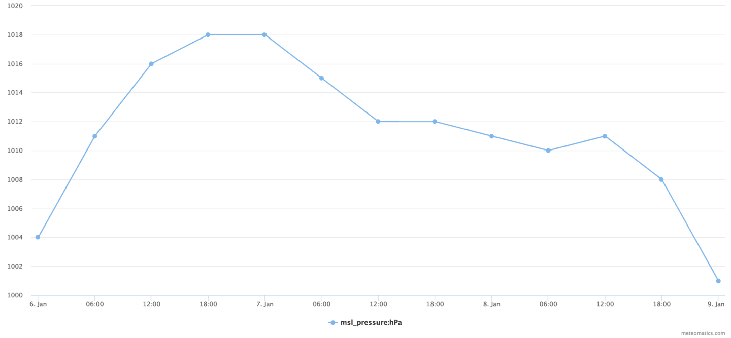
Gives the pressure adjusted to sea level. To adjust the pressure to the mean sea level atmospheric conditions such as temperature are taken into account.This parameter is also known as QFF.
msl_pressure:<unit>
Available units: hPa, Pa, psi
Examples
- Display the predicted evolution of the adjusted pressure for the next three days over Berlin. https://api.meteomatics.com/2025-06-30T00:00:00Z--2025-07-03T00:00:00Z:PT6H/msl_pressure:hPa/47.412164,9.340652/html

Note (especially for aviation):
It is possible to get from weather station data the pressure that is adjusted to mean sea level by applying the standard atmosphere of ICAO. This mean sea level pressure is also known as QNH.
msl_pressure_icao:<unit>Available units: hPa, Pa
Examples
- Query QNH from station observations for Bern via WMO ID:
https://api.meteomatics.com/2025-06-29T00Z--2025-06-30T00Z:PT1H/msl_pressure_icao:hPa/wmo_066700/html?source=mix-obs&on_invalid=fill_with_invalid
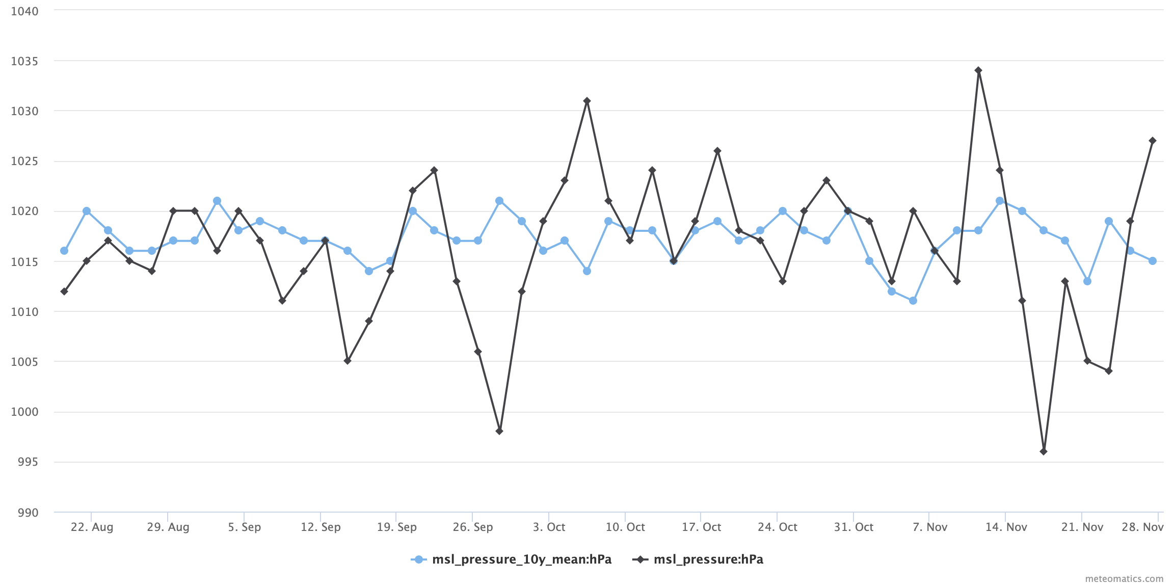
Mean Pressure Adjusted to Sea Level over the Last 10 Years
Gives the mean adjusted pressure (QFF) over the last 10 years on a certain date at a specific location.
msl_pressure_10y_mean:<unit>Available units: hPa, psi
Examples:
- Compare the mean adjusted pressure of the last ten years with the adjusted pressure of 2022.
Current situation:
https://api.meteomatics.com/2025-06-30T12:00:00ZP100D:P2D/msl_pressure_10y_mean:hPa,msl_pressure:hPa/50,10/html - The mean adjusted pressure in winter compared to the 10 years mean:
validdate;msl_pressure_10y_mean:hPa;msl_pressure:hPa
2021-10-01T12:00:00Z;1017;1020
2021-11-01T12:00:00Z;1017;1005
2021-12-01T12:00:00Z;1019;997
2022-01-01T12:00:00Z;1020;1028
2022-02-01T12:00:00Z;1007;1017
Current situation:
https://api.meteomatics.com/2025-06-30T12:00:00ZP4M:P1M/msl_pressure_10y_mean:hPa,msl_pressure:hPa/50,10/csv

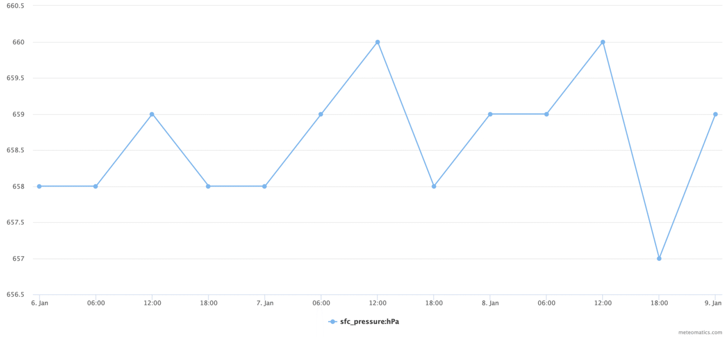
Surface Pressure
Gives the surface pressure also known as QFE.sfc_pressure:<unit>
Available units: hPa, Pa, psi
Examples
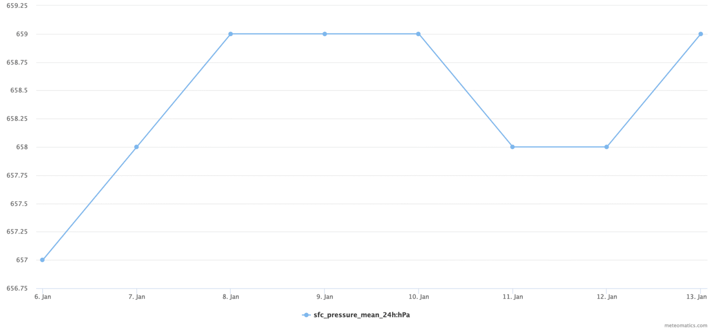
- Show the predicted surface pressure evolution for the next three days over La Paz, the capital of Bolivia (3640 m above sea level). https://api.meteomatics.com/2025-06-30T00:00:00Z--2025-07-03T00:00:00Z:PT6H/sfc_pressure:hPa/-16.489689,-68.119293/html
- The predicted surface pressure for the next two days in json format. https://api.meteomatics.com/2025-06-30T00:00:00Z--2025-07-03T00:00:00Z:PT6H/sfc_pressure:hPa/-16.489689,-68.119293/json
{"version":"3.0","user":"api-test","dateGenerated":"2022-01-06T08:40:01Z","status":"OK","data":[{"parameter":"sfc_pressure:hPa","coordinates":[{"lat":-16.489689,"lon":-68.119293,"dates":[{"date":"2022-01-06T00:00:00Z","value":658},{"date":"2022-01-06T06:00:00Z","value":658},{"date":"2022-01-06T12:00:00Z","value":659},{"date":"2022-01-06T18:00:00Z","value":658},{"date":"2022-01-07T00:00:00Z","value":658},{"date":"2022-01-07T06:00:00Z","value":659},{"date":"2022-01-07T12:00:00Z","value":660},{"date":"2022-01-07T18:00:00Z","value":658},{"date":"2022-01-08T00:00:00Z","value":659},{"date":"2022-01-08T06:00:00Z","value":659},{"date":"2022-01-08T12:00:00Z","value":660},{"date":"2022-01-08T18:00:00Z","value":657},{"date":"2022-01-09T00:00:00Z","value":659}]}]}]} - The current surface pressure of Switzerland in png format. https://api.meteomatics.com/now/sfc_pressure:hPa/switzerland:0.01,0.01/png

Surface Pressure Mean
Gives the surface pressure mean over the given interval.sfc_pressure_mean_<interval>:<unit>
Available intervals: 1h - 24h (spacing: 1 h)
Available units: hPa, Pa, psi
Examples
- Show the forecast for the surface pressure 24h mean for the next seven days over La Paz (Bolivia). https://api.meteomatics.com/2025-06-30T00:00:00Z--2025-07-07T00:00:00Z:PT24H/sfc_pressure_mean_24h:hPa/-16.489689,-68.119293/html
Pressure at Higher Altitudes
The atmospheric pressure is available at any height level above ground up to 20 km.pressure_<level>:<unit>
Available altitude levels: 1m - 20000m (continuously)
pressure_mean_<level>_<interval>:<unit>
Available intervals: 1h - 24h (spacing: 1 h)
Available units: hPa, Pa, psi
Examples
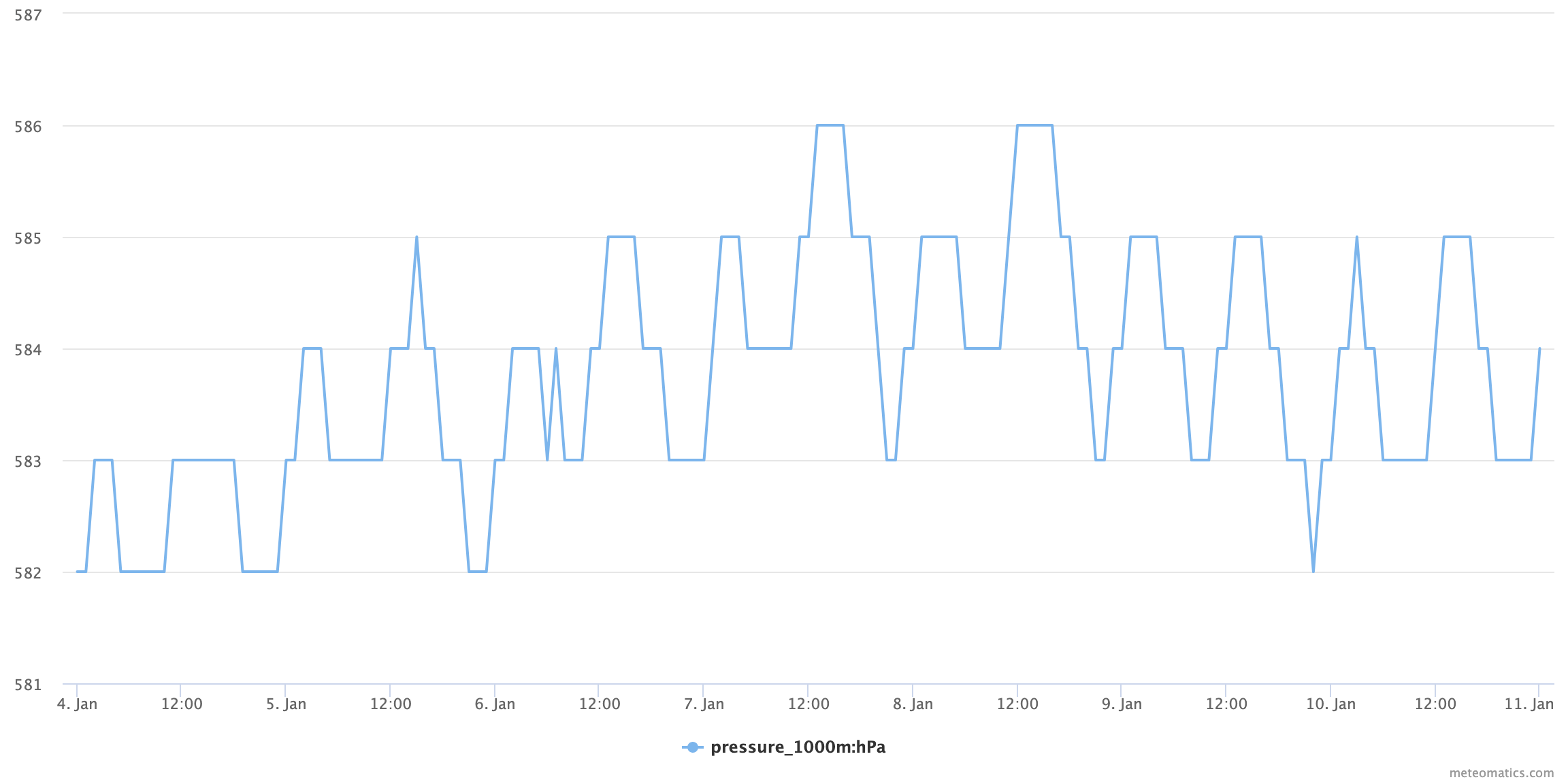
- Show the forecast of the pressure in 1000m height above ground for the next seven days over La Paz (Bolivia).
Current situation:
https://api.meteomatics.com/2025-06-30T00:00:00Z--2025-07-07T00:00:00Z:PT1H/pressure_1000m:hPa/-16.489689,-68.119293/html
Atmospheric Density
The density of air at any height level above ground up to 10 km.air_density_<level>:<unit>
Available altitude levels: 2m - 20000m (continuously)
Available flight levels: FL10 - FL900 (continuously)
Available units: kgm3
air_density_mean_<level>_<time>:<unit>
Available intervals: 1h - 24h (spacing: 1 h)
Available units: kgm3
Examples
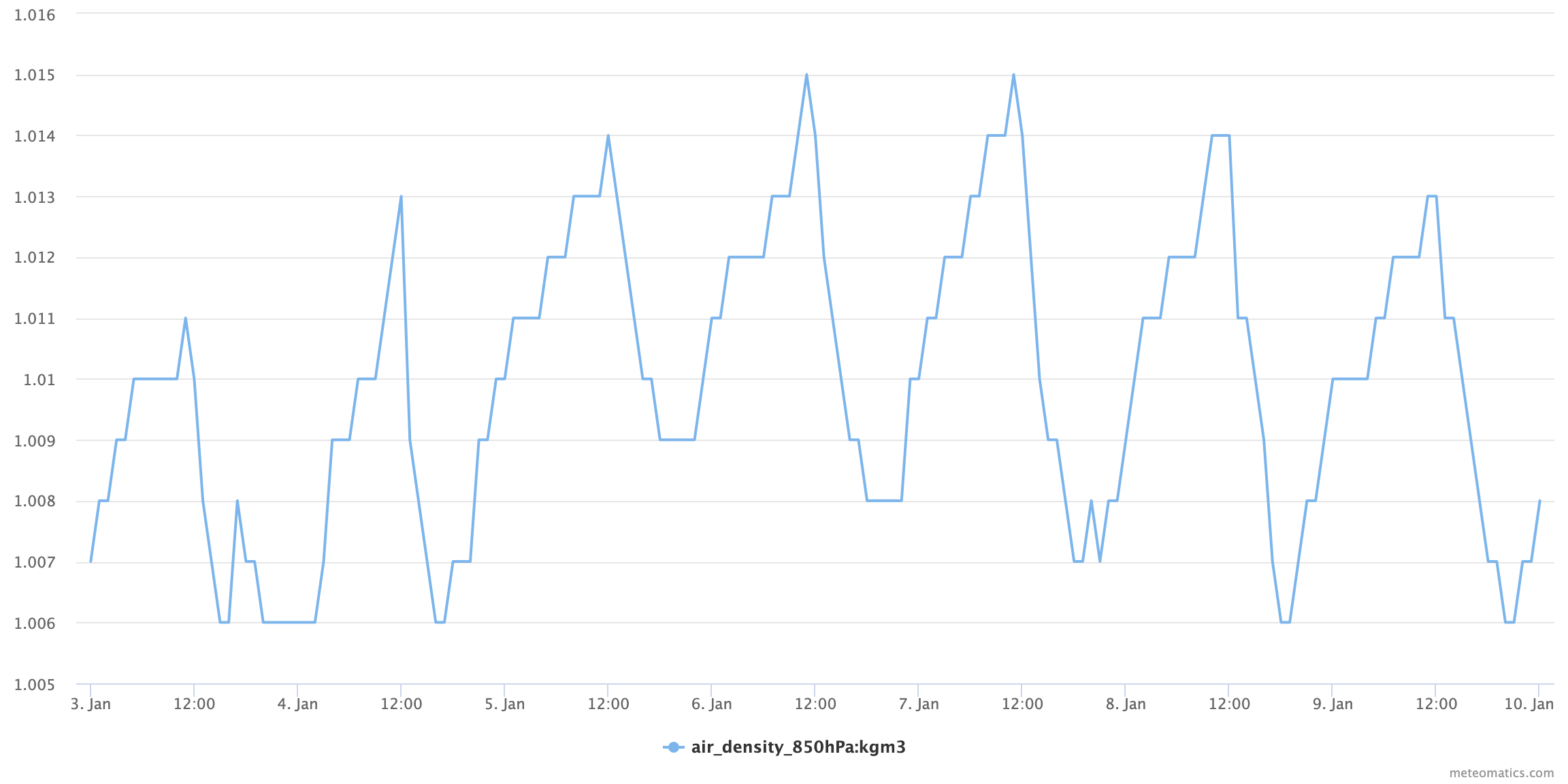
- Show the forecast of the air density for the next seven days over La Paz (Bolivia).
Current situation:
https://api.meteomatics.com/2025-06-30T00:00:00Z--2025-07-07T00:00:00Z:PT1H/air_density_850hPa:kgm3/-16.489689,-68.119293/html
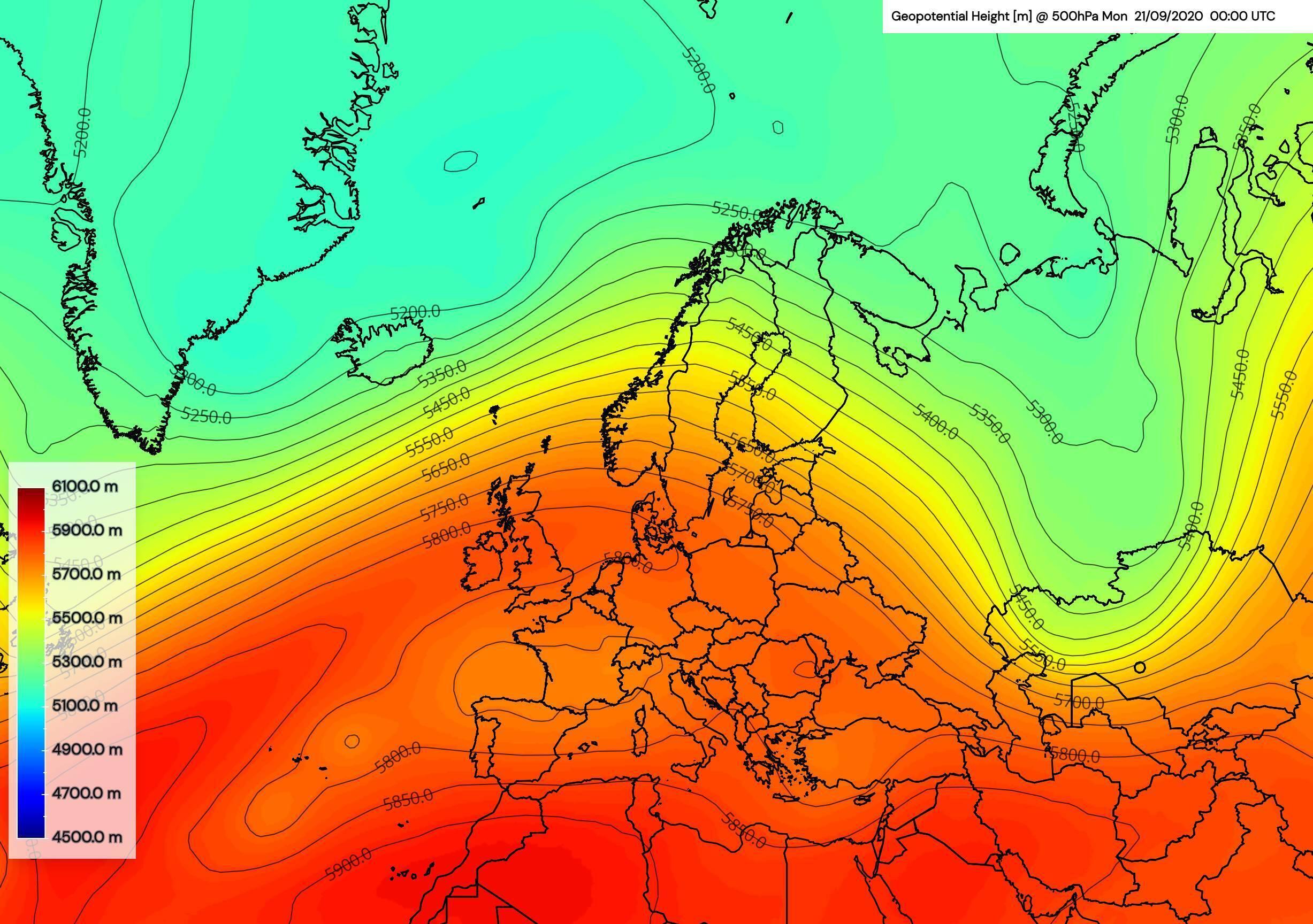
Geopotential Height
Gives the geopotential height in meters or decameters at the indicated level. The geopotential height differs from geometric height (elevation above sea level) and takes into account the variation of gravity with latitude and elevation.
geopotential_height_<level>:<unit>Available levels (global): 1000hPa, 975hPa, 950hPa, 925hPa, 900hPa, 875hPa, 850hPa, 825hPa, 800hPa, 775hPa, 750hPa, 700hPa, 650hPa, 600hPa, 550hPa, 500hPa, 450hPa, 400hPa, 350hPa, 300hPa, 250hPa, 200hPa, 150hPa, 100hPa, 70hPa, 50hPa, 10hPa
Available flight levels: FL10 - FL900 (continuously)
Available units: m, dam
Examples
- MetX chart showing geopotential at 500 hPa level (shading and isonlines):
Current situation:
https://api.meteomatics.com/2025-06-30T00:00:00Z--2025-07-03T00:00:00Z:PT1H/geopotential_height_500hPa:m/46.5468,7.9826/html -
The geopotential height at 500 hPa at the "Jungfrau" in csv format
https://api.meteomatics.com/now/t_500hPa:C,gh_500hPa:m/46.5468,7.9826/csv
validdate;t_500hPa:C;gh_500hPa:m
2018-01-01T00:00:00Z;-22.1;5539.3

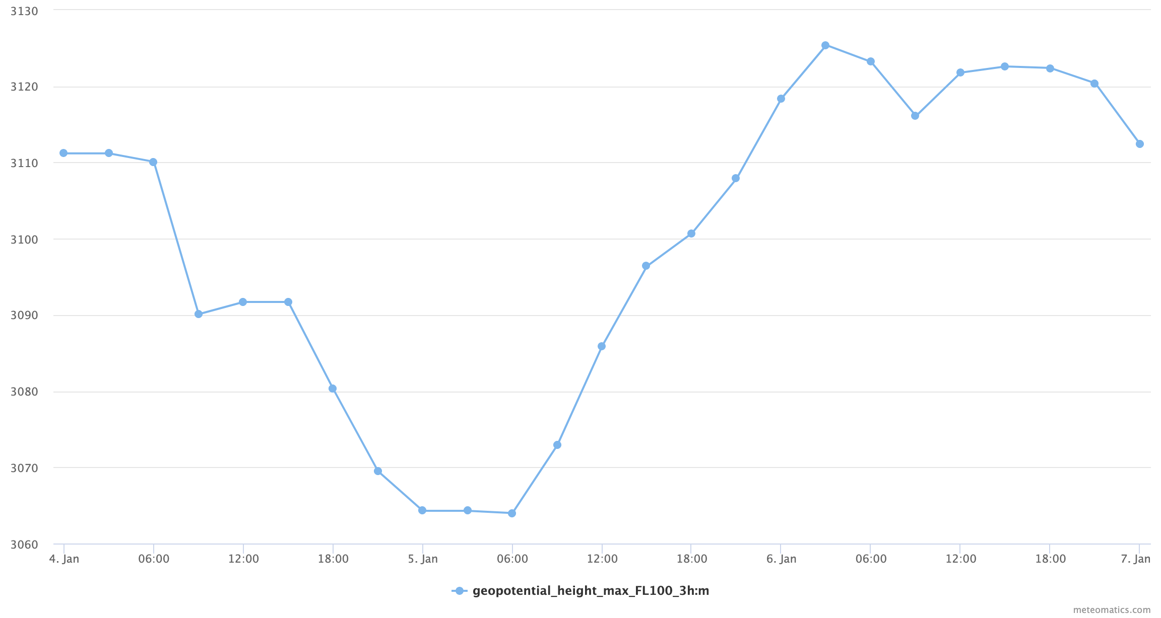
Interval Values of Geopotential Height
Gives the mean, maximum or minimum geopotential at the indicated flight level over the indicated duration.
geopotential_height_<measure>_<level>_<interval>:<unit>Available flight levels: FL10 - FL900 (continuously)
Available measures: mean, min, max
Available intervals: 1h, 3h, 6h, 12h, 24h
Available units: m, dam
Examples
-
Create a time series for the maximum geopotential at FL100 for Los Angeles using 3 hour intervals.
-
Current situation:
https://api.meteomatics.com/2025-06-30T00:00:00Z--2025-07-03T00:00:00Z:PT3H/geopotential_height_max_FL100_3h:m/34.0522,118.2437/html?source=mix

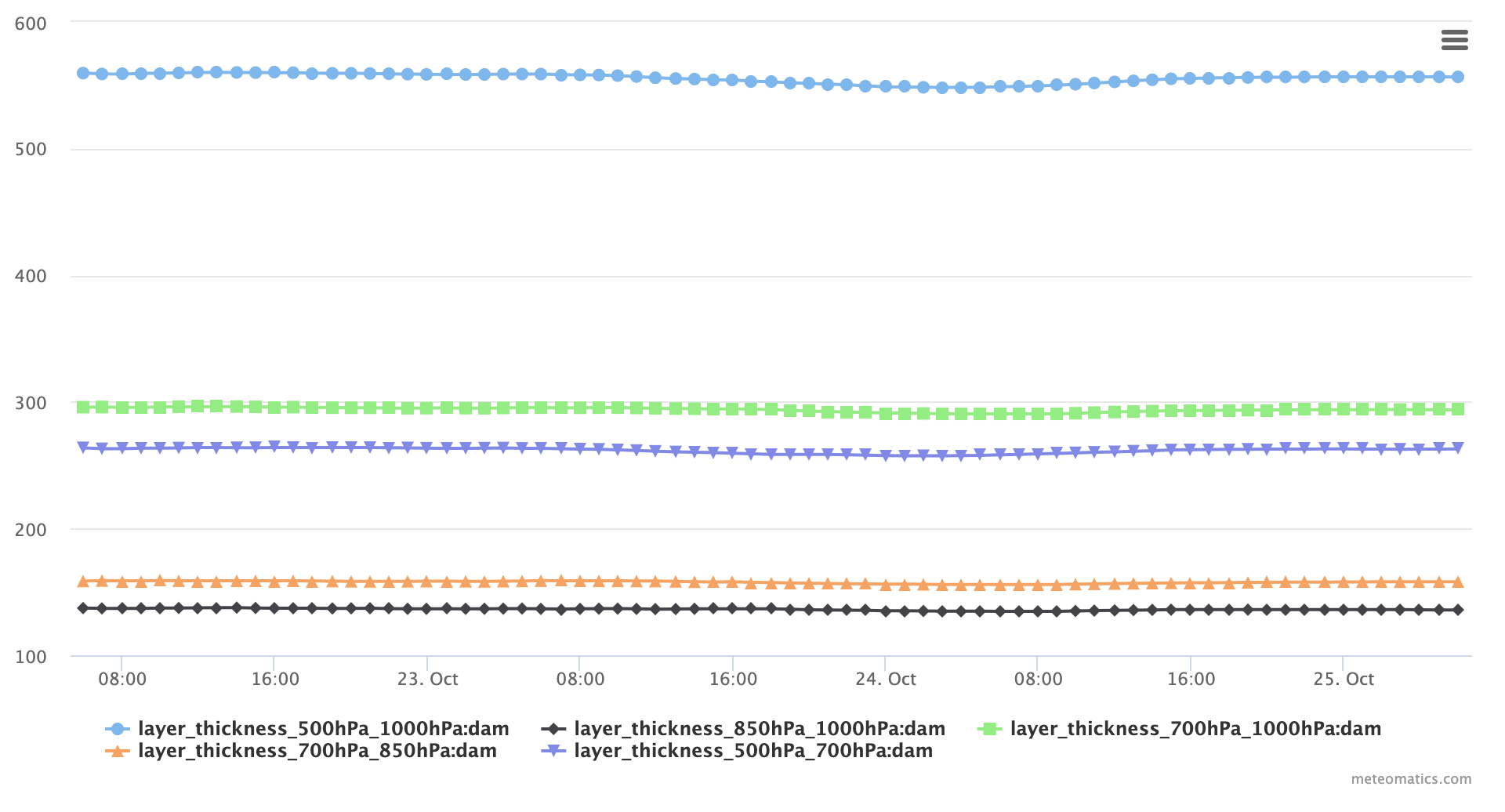
Layer Thickness
Layer thickness is a measure of how warm or cold a layer of the atmosphere is, usually a layer in the lowest 5 km (17,000 feet) of the troposphere; high values mean warm air, and low values mean cold air. Rain and snow are equally likely when the 500-1000 hPa thickness is about 5225 gpm (or 522 dam). Rain is rare when the 500-1000 hPa thickness is less than 5190 gpm. Snow is extremely rare when the 500-1000 hPa thickness is greater than 5395 gpm.
layer_thickness_<upper_level>_<lower_level>:<unit>layer_thickness_500hPa_1000hPa:<unit>
layer_thickness_500hPa_700hPa:<unit>
layer_thickness_700hPa_1000hPa:<unit>
layer_thickness_700hPa_850hPa:<unit>
layer_thickness_850hPa_1000hPa:<unit>
Available units: m, dam
Example
-
The different layer_thickness combinations in comparison: