Weather Warnings
All weather warning parameters are inspired by the descriptions of the DWD.
Frost Warning | Heavy Rain Warning | Incessant Rain Warning | Snow Warning | Wind Warning | Fog Warning | Thunderstorm Warning | Satellite-based Thunderstorm Warning
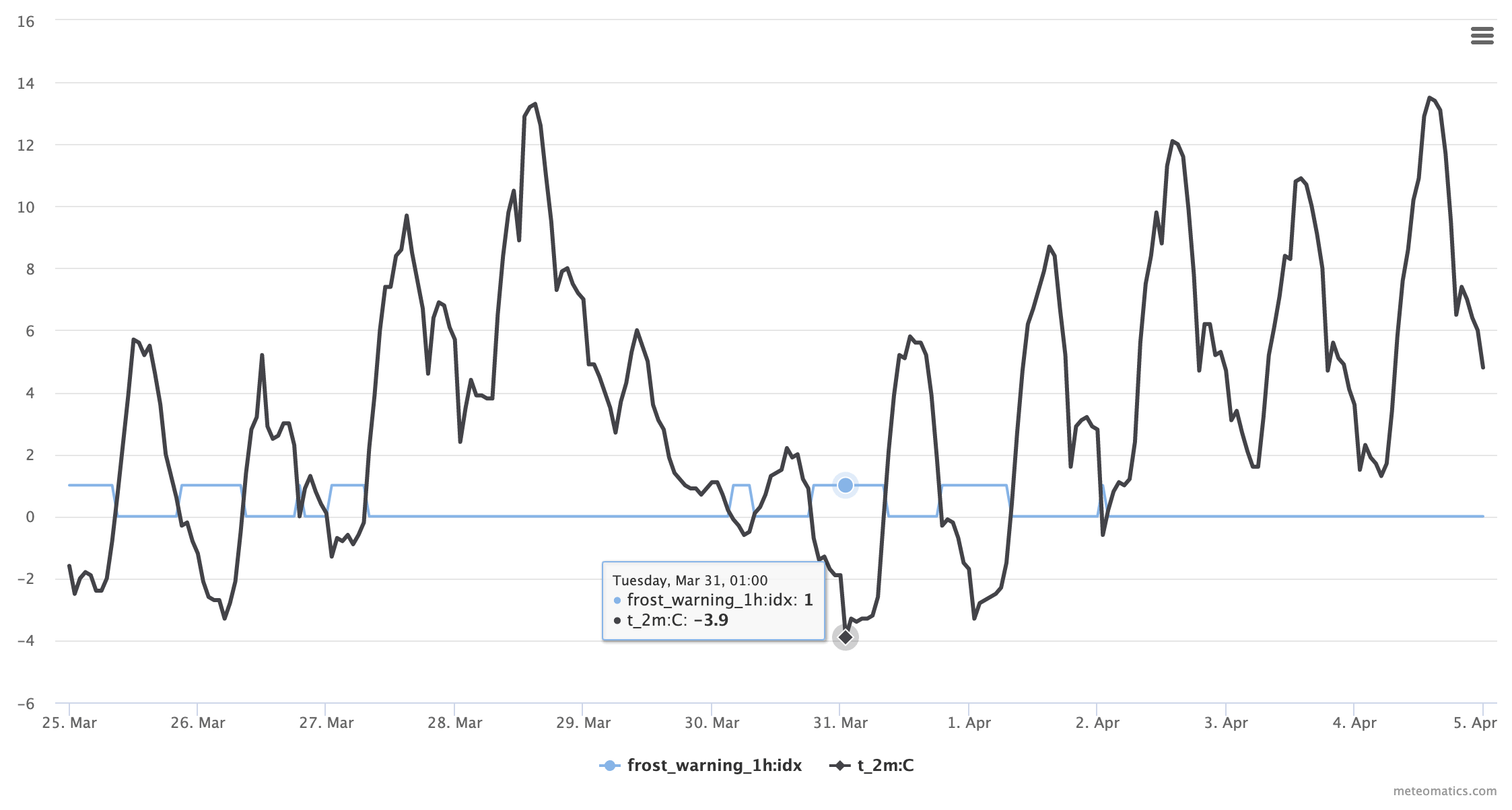
Frost Warning
The frost parameter depicts whether the temperature at a height of 2 meters falls below 0 degrees Celsius.
The frost warning corresponds to the US freezing warning, which is issued when surface temperatures are expected to drop below freezing (32 degrees Fahrenheit). The US frost definition corresponds to the definition of ground frost, which describes the formation of thin ice crystals on the ground or other surfaces when the temperatures of the Earth's surface falls below 32 degrees Fahrenheit.
frost_warning_<interval>:idxAvailable intervals: 1h, 2h, 3h, 6h, 12h, 24h
| Warning | Description | Temperature Limits |
|---|---|---|
| 0 | No frost | > 0°C |
| 1 | Frost | ≤ 0°C and > -10°C |
| 2 | Severe Frost | ≤ -10°C |
Example:
-
Surface temperature along with the frost warning index for the end of March/beginning of April, 2020 in St. Gallen:
Current Situation:
https://api.meteomatics.com/2026-07-21T00:00:00Z--2026-07-26T00:00:00Z:PT1H/frost_warning_1h:idx,t_0m:C/47.412164,9.340652/html

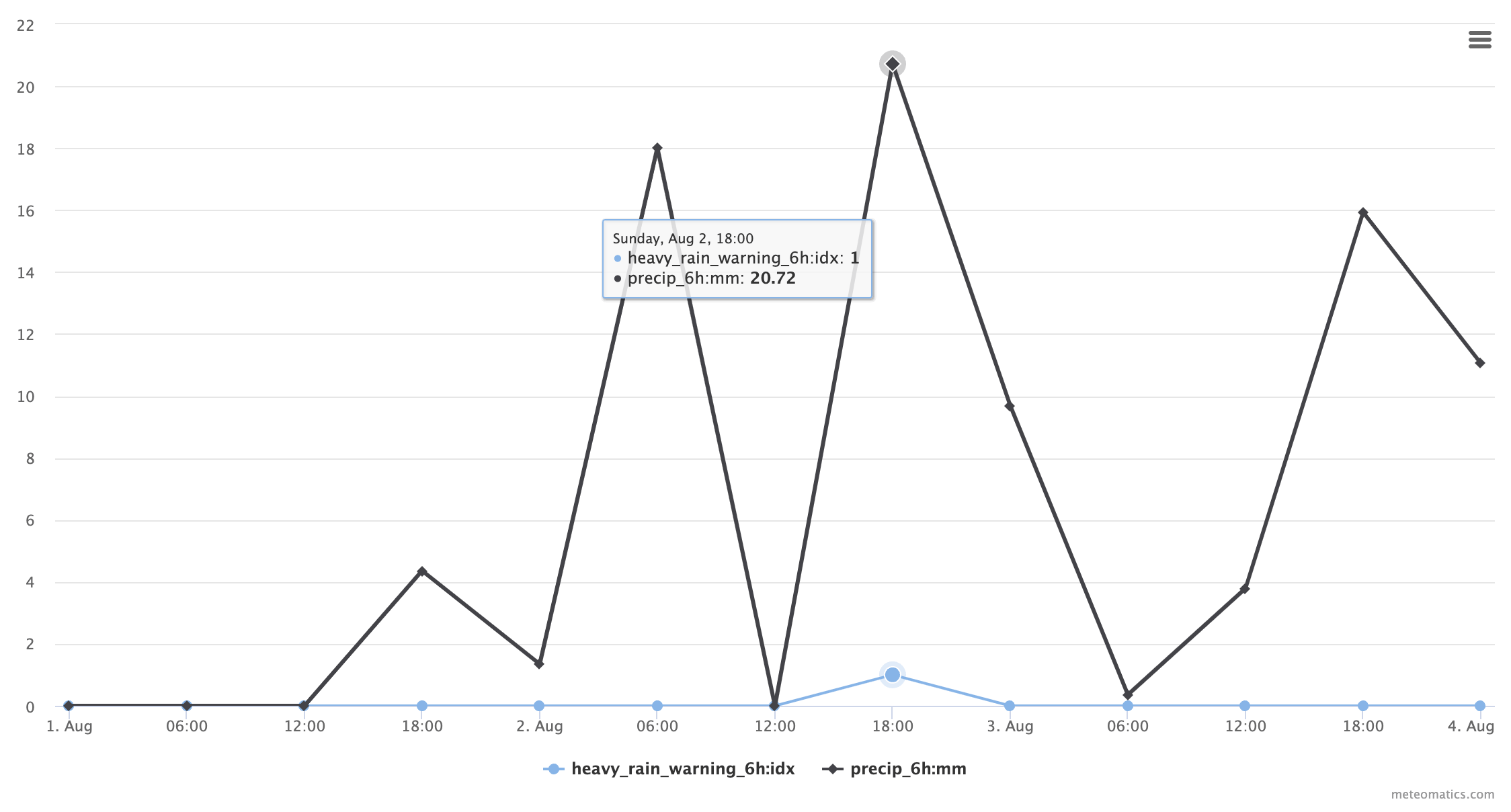
Heavy Rain Warning
This parameter indicates if any heavy rain events will occur in a given time interval.
heavy_rain_warning_<interval>:idxAvailable intervals: 1h, 2h, 3h, 6h, 12h, 24h
| Warning | Description | Limits for 1h | Limits for 6h |
|---|---|---|---|
| 0 | No severe rainfall | < 15mm | < 20mm |
| 1 | Heavy Rainfall | 15mm to 25mm | 20 mm to 35mm |
| 2 | Severe Heavy Rainfall | 25mm to 40mm | 35 mm to 60mm |
| 3 | Extreme Heavy Rainfall | > 40mm | > 60mm |
Example:
-
Severe heavy rainfall in St. Gallen on August 2nd, 2018:
Current situation:
https://api.meteomatics.com/2026-07-21T00:00:00Z--2026-07-24T00:00:00Z:PT6H/heavy_rain_warning_6h:idx,precip_6h:mm/47.4245,9.3767/html?source=mix

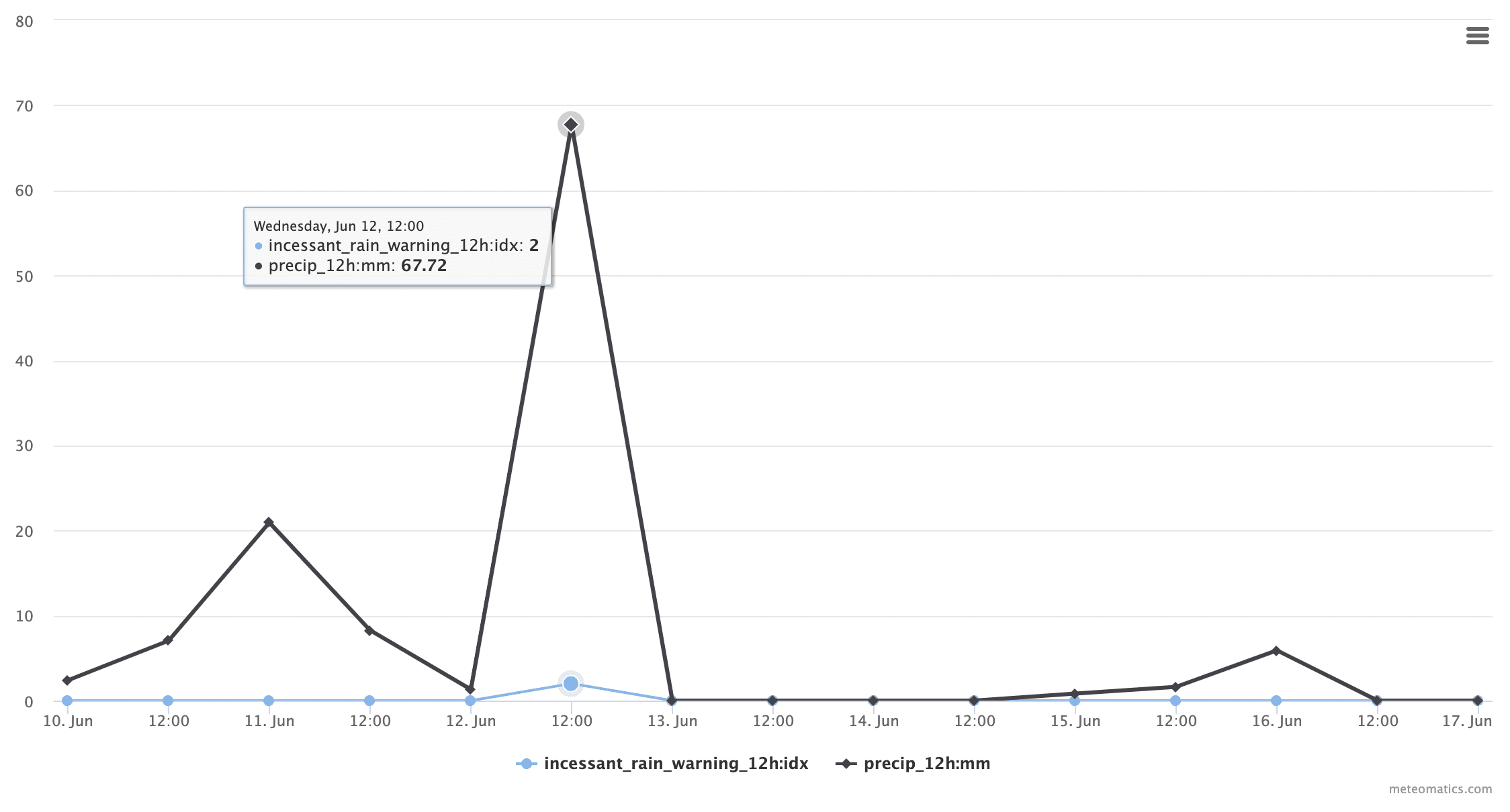
Incessant Rain Warning
This parameter indicates if any incessant rain events will occur in a given time interval. A rain event is defined incessant if it lasts for at least 60 minutes.
incessant_rain_warning_<interval>:idxAvailable intervals: 12h, 24h, 48h, 72h
| Warning | Description | Limits for 12h | Limits for 24h | Limits for 48h | Limits for 72h |
|---|---|---|---|---|---|
| 0 | No incessant rainfall | < 25mm | < 30mm | < 40mm | < 60mm |
| 1 | Incessant Rainfall | 25mm to 40mm | 30mm to 50mm | 40mm to 60mm | 60mm to 90mm |
| 2 | Severe Incessant Rainfall | 40mm to 70mm | 50mm to 80mm | 60mm to 90mm | 90mm to 120mm |
| 3 | Extreme Incessant Rainfall | > 70mm | > 80mm | > 90mm | > 120mm |
Example:
-
Severe incessant rainfall in St. Gallen on June 12th, 2019:
Current situation:
https://api.meteomatics.com/2026-07-21T00:00:00Z--2026-07-24T00:00:00Z:PT12H/incessant_rain_warning_12h:idx,precip_12h:mm/47.4245,9.3767/html?source=mix

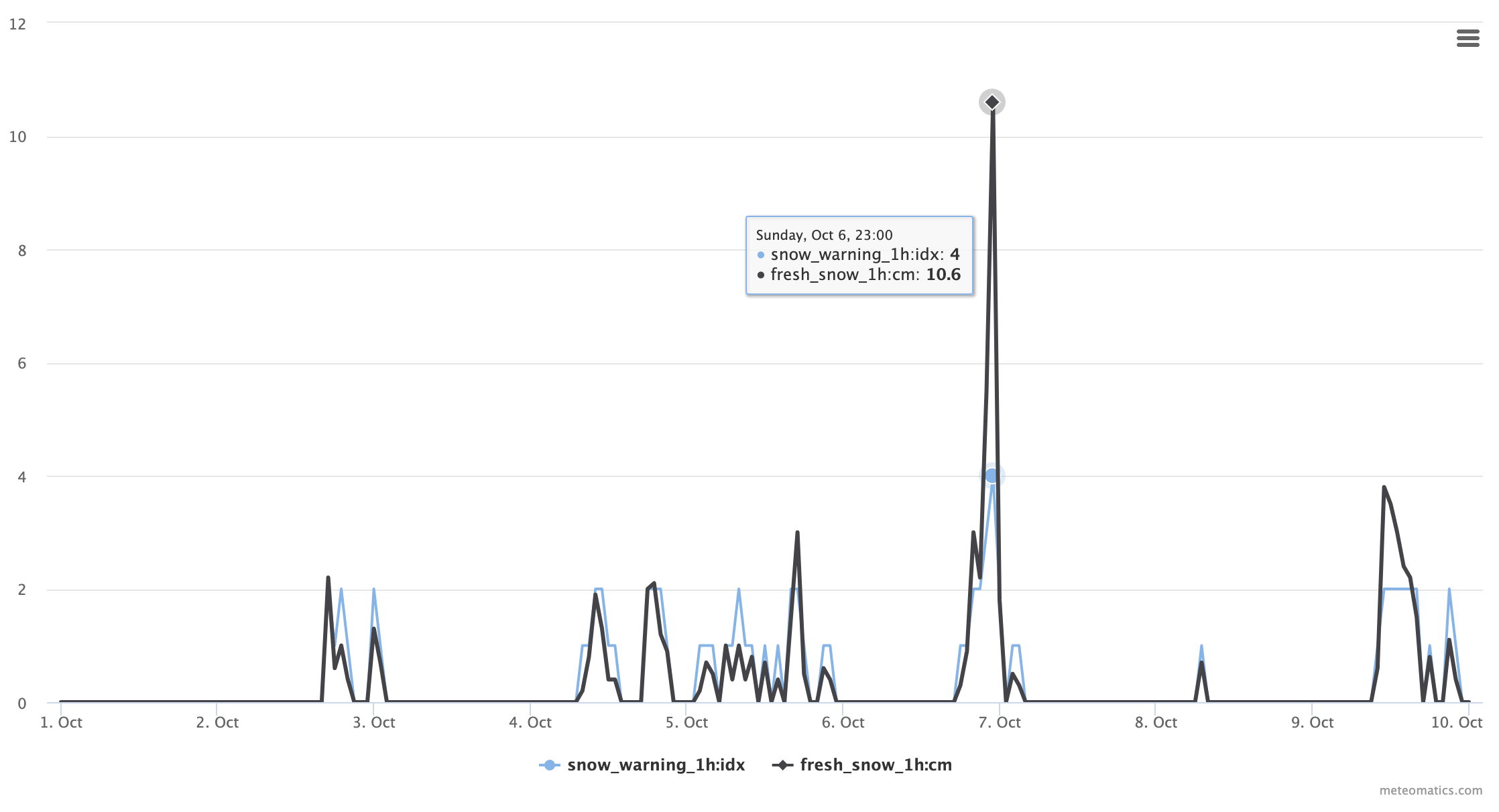
Snow Warning
This parameter indicates if any severe snow fall will occur in a given time interval.
snow_warning_<interval>:idxAvailable intervals: 1h, 2h, 3h, 6h, 12h, 24h, 48h
| Warning | Description | Limits for 1h | Limits for 6h | Limits for 12h | Limits for 24h | Limits for 48h |
|---|---|---|---|---|---|---|
| 0 | No severe snowfall | < 1cm | ||||
| 1 | Snowfall | < 1cm | < 5cm | < 10cm | < 15cm | < 20cm |
| 2 | Snowfall | below 800m: 1cm to 2cm above 800m: 1cm to 4cm | below 800m: 5cm to 10cm above 800m: 5cm to 20cm | below 800m: 10cm to 15cm above 800m: 10cm to 30cm | below 800m: 15cm to 30cm above 800m: 15cm to 40cm | 20cm to 50cm |
| 3 | Heavy Snowfall | below 800m: 2cm to 4cm above 800m: 4cm to 6cm | below 800m: 10cm to 20cm above 800m: 20cm to 30cm | below 800m: 15cm to 25cm above 800m: 30cm to 50cm | below 800m: 30cm to 40cm above 800m: 40cm to 60cm | 50cm to 70cm |
| 4 | Extreme Heavy Snowfall | below 800m: > 4cm above 800m: > 6cm | below 800m: > 20cm above 800m: > 30cm | below 800m: > 25cm above 800m: > 50cm | below 800m: > 40cm above 800m: > 60cm | > 70cm |
Example:
-
Severe snow fall event on Säntis on October 6th, 2019:
Current situation:
https://api.meteomatics.com/2026-07-21T00:00:00Z--2026-07-24T00:00:00Z:PT1H/snow_warning_1h:idx,fresh_snow_1h:cm/47.249349,9.342348/html?source=mix

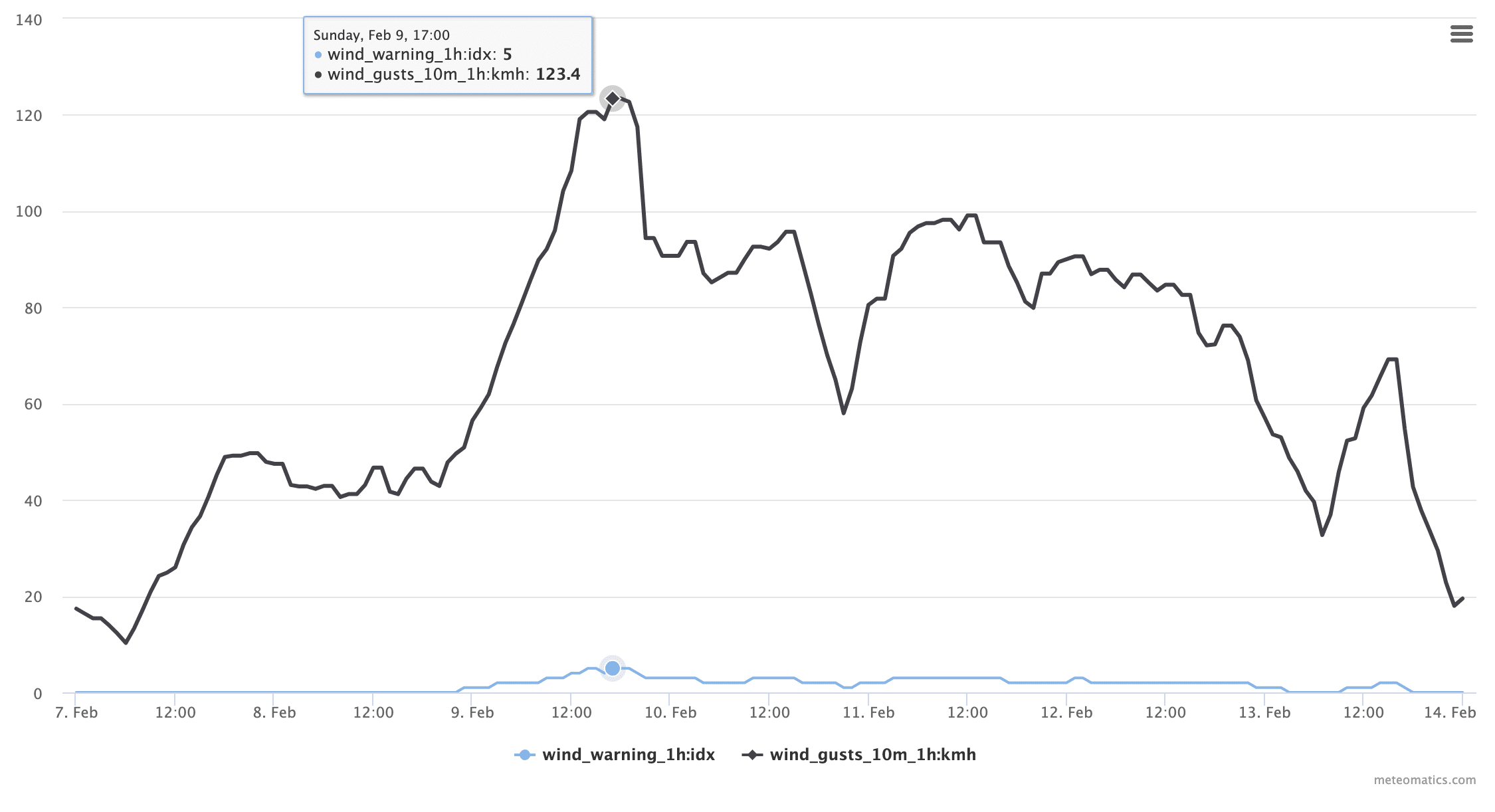
Wind Warning
This parameter indicates if any dangerous wind speeds will occur in a given time interval. Wind speeds are considered dangerous if they exceed 50 km/h.
wind_warning_<interval>:idxAvailable intervals: 1h, 2h, 3h, 6h, 12h, 24h
| Warning | Description | Limits |
|---|---|---|
| 0 | No severe wind conditions | < 50km/h |
| 1 | Wind Gusts | 50km/h to 64km/h |
| 2 | Squall | 65km/h to 89km/h |
| 3 | Severe Squall | 90km/h to 104km/h |
| 4 | Violent squall | 105km/h to 119km/h |
| 5 | Gale-Force Winds | 120km/h to 139km/h |
| 6 | Extreme Gale-Force Winds | > 140km/h |
Example:
-
Severe wind speeds with a warning of 5 at the North Sea on February 9th, 2020:
Current situation:
https://api.meteomatics.com/2026-07-21T00:00:00Z--2026-07-24T00:00:00Z:PT1H/wind_warning_1h:idx,wind_gusts_10m_1h:kmh/53.711657,7.889181/html?source=mix

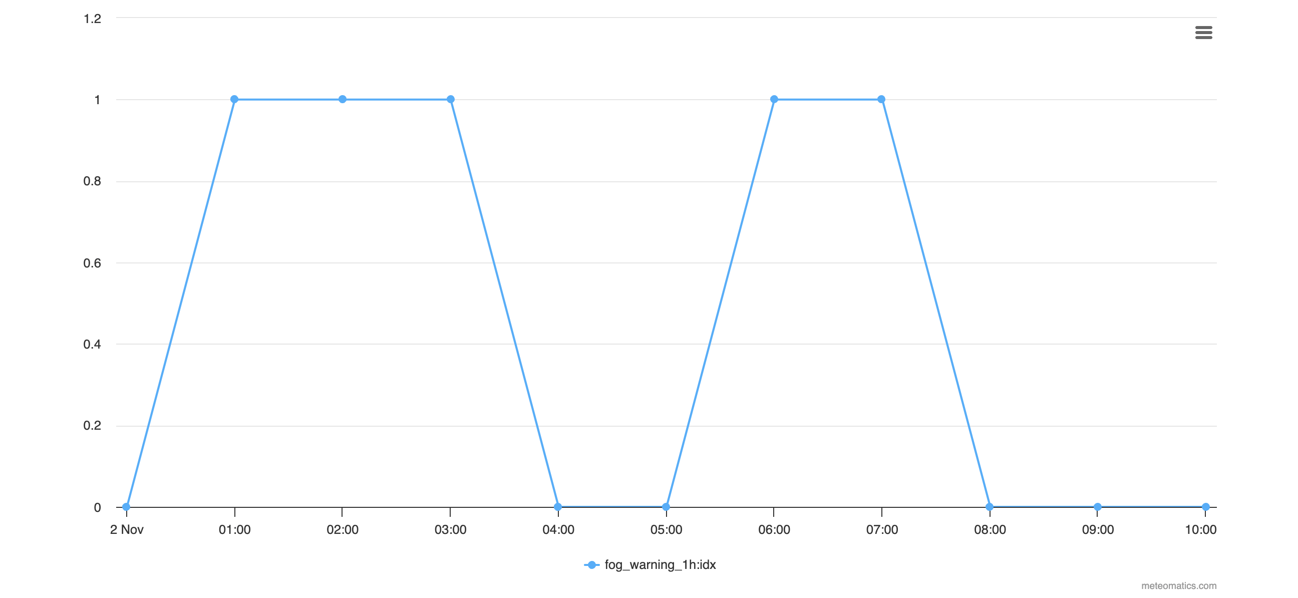
Fog Warning
This parameter indicates if any fog will occur in an interval of one hour.
fog_warning_1h:idx| Warning | Description | Criteria |
| 0 | No fog | |
| 1 | Fog | The visibility has been less than 150 m in the past hour |
Example:
-
Fog warning around Cremona, Italy on November 3rd, 2023:
https://api.meteomatics.com/2023-11-02T00:00:00Z--2023-11-02T10:30:00Z:PT1H/fog_warning_1h:idx/45,10/html?source=mixCurrent situation:
https://api.meteomatics.com/2026-07-21T00:00:00Z--2026-07-26T00:00:00Z:PT1H/fog_warning_1h:idx/45,10/html?source=mix

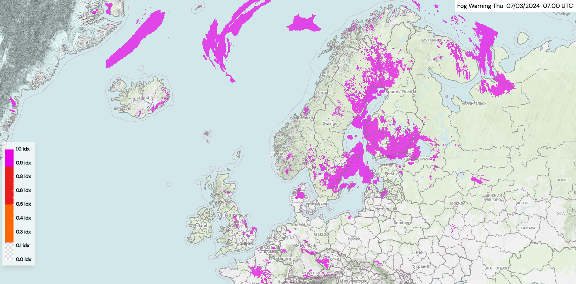
- Fog warning for Northern Europe on the 7th of March, 2024 plotted with MetX.

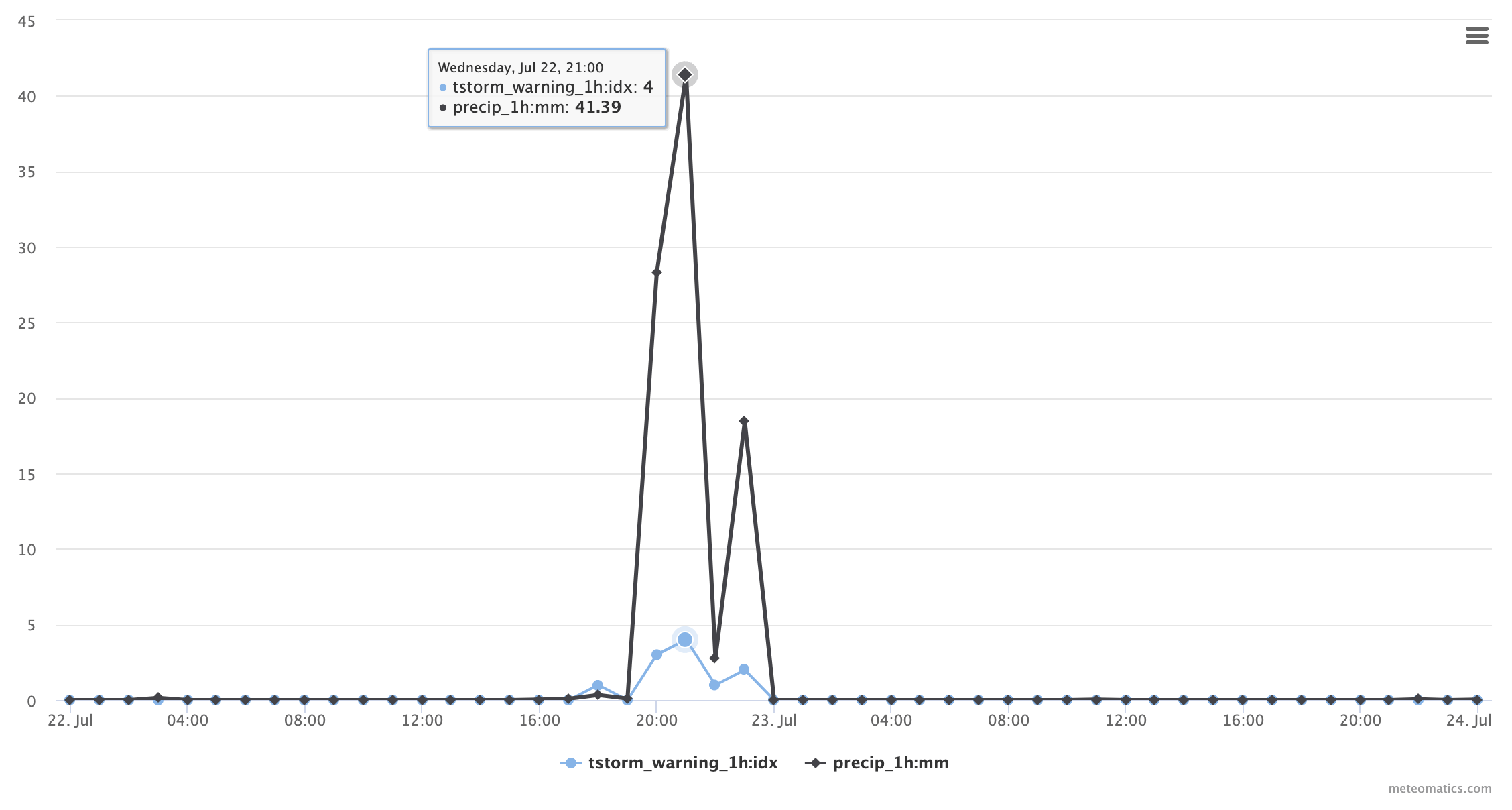
Thunderstorm Warning
This parameter indicates if any thunderstorms will occur in a given time interval.
tstorm_warning_<interval>:idxAvailable intervals: 1h, 2h, 3h, 6h, 12h, 24h
| Warning | Description | Criteria |
| 0 | No thunderstorms | |
| 1 | Thunderstorm | Occurrence of electric discharge |
| 2 | Heavy thunderstorm | Occurrence of electric discharge in combination with strong gale, heavy rain or hail |
| 3 | Severe thunderstorm | Occurrence of electric discharge in combination with strong gale, heavy rain or hail where at least on accompanying feature has warning level |
| 4 | Severe thunderstorm with extreme squalls and heavy rainfall | Occurrence of electric discharge in combination with strong gale, heavy rain or hail where at least on accompanying feature has alerting level |
Example:
-
Thunderstorm warning of 4 around Munich with corresponding lightning strikes on June 22nd, 2019:
Current situation:
https://api.meteomatics.com/2026-07-21T00:00:00Z--2026-07-26T00:00:00Z:PT1H/tstorm_warning_1h:idx,precip_1h:mm/47.412164,9.340652/html?source=mix

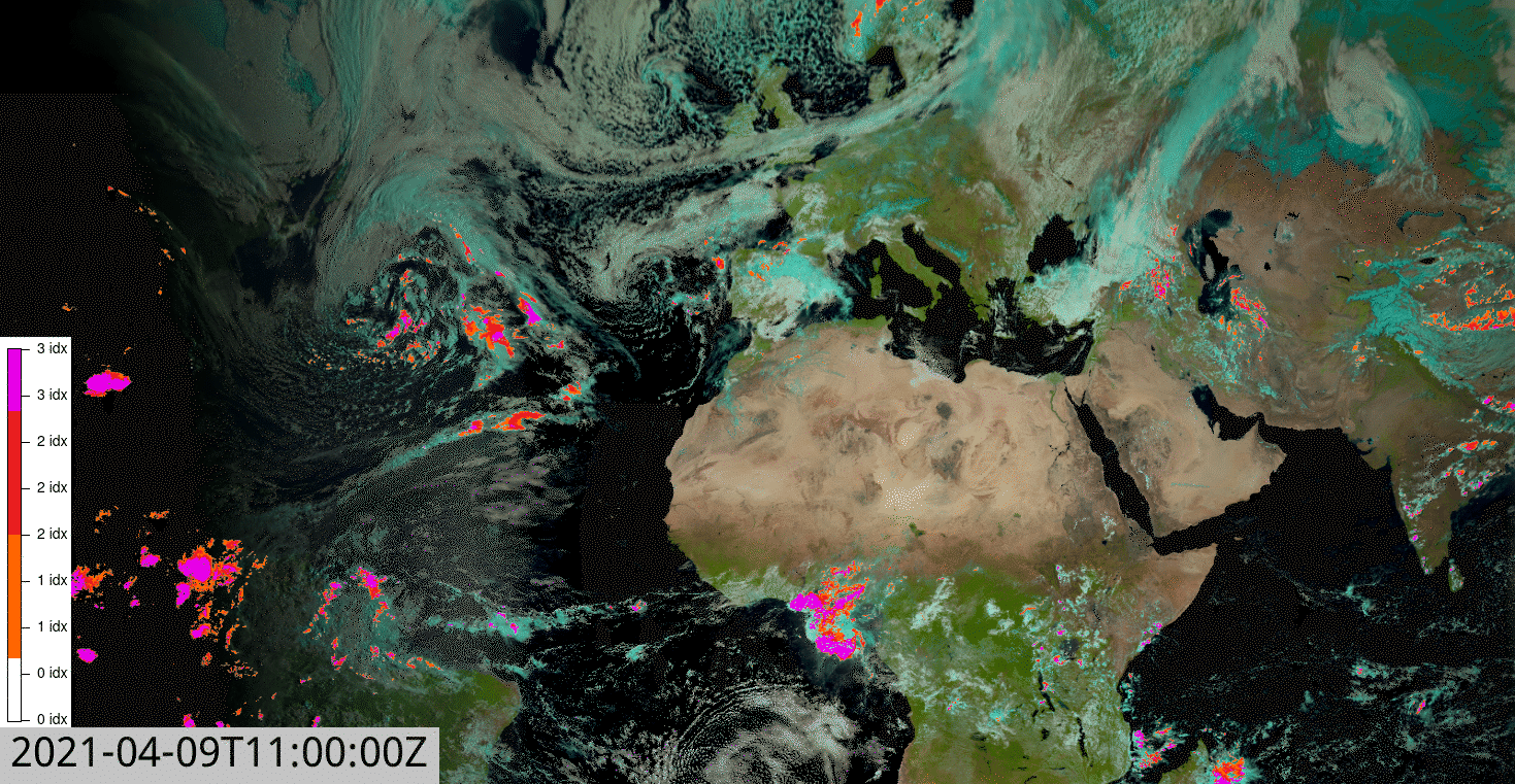
Satellite-based Thunderstorm Warning
Satellite-based parameter for detection of thunderstorms. The index provides values between 0 and 3:
sat_storm_warning:idx| Value | Meaning |
| 0 | No storm cells present |
| 1 | Storm cells present |
| 2 | Heavy thunderstorms |
| 3 | Severe thunderstorms |
Example:
-
Thunderstorm warning on April 9th, 2021:
Current situation:
https://api.meteomatics.com/2026-07-21T00:00:00Z/sat_storm_warning:idx/60,-12_35,30:0.05,0.05/html_map